
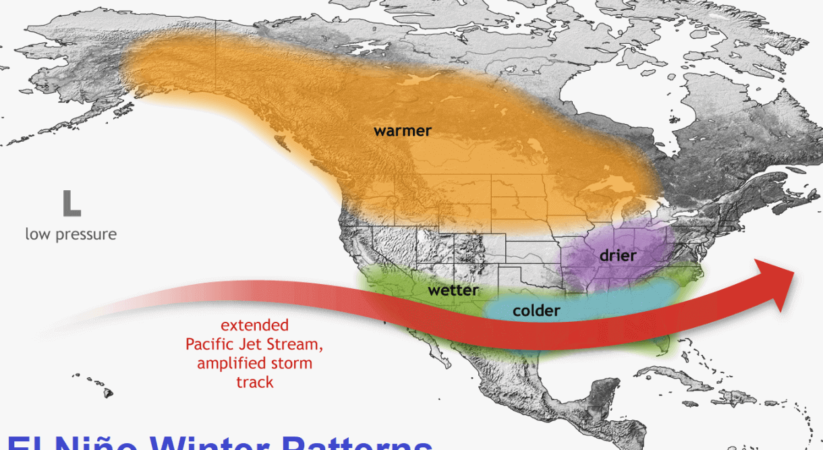

The global weather system is complex, with many large and small weather drivers. A growing El Niño event will be the main influence in the 2023/2024 Winter across the Northern Hemisphere. But there is also the infamous Polar Vortex and a new anomaly high in the Stratosphere.
The image below shows the actual pressure anomalies of the 2009/2010 Winter season. That Winter has featured a very interesting dance between the El Niño and the Polar Vortex, creating a very impressive cold Winter pattern in the process.
THE WINTER TRIO
There are always various factors and influences that shape every weather season. Some are big, but most are small. How they work together in a very fine and sensitive balance determines the final weather outcome.
Based on the latest analysis, there are three large-scale factors that we are looking at closely for the upcoming Winter season:
- El Niño event (ENSO)
- Stratospheric Polar Vortex
- Quasi-Biennial Oscillation (QBO)
Each of these factors can have different phases: warm, cold, positive, negative, east, west, and so on. So you can imagine that each year, you can have a different combination of these factors, creating a different Winter weather outcome.
We will quickly review each one and look at their role for this Winter. As you will see, they all complement each other in a very delicate balance of power.
EL NINO SOUTHERN OSCILLATION
El Niño Southern Oscillation (or ENSO) is a region of the equatorial Pacific Ocean that changes between warm and cold phases. Typically, there is a phase change around every 1-3 years.
We are currently entering a warm phase called El Niño. The cold ENSO phase is called La Niña, which was active in the past three winters.
You can see the El Niño in NOAA’s latest ocean anomaly analysis below. It stands out as an area of above-normal ocean temperatures across the equatorial Pacific Ocean. This anomaly affects the atmosphere but also tells us that the weather patterns are changing globally.


prednisone online buy – https://apreplson.com/ order prednisone 20mg for sale
king88.international hỗ trợ nhiều ngân hàng và ví điện tử, giao dịch cực kỳ thuận tiện
nhacaijun88.dev tỷ lệ cược cao, chơi vài ván là dễ có lợi nhuận rõ rệt
keonhacaivn.online khuyến mãi mỗi ngày, quà tặng giá trị cho cả người mới và thành viên cũ
cakhiatv.uk.com tỷ lệ cược hấp dẫn, chơi vài ván là dễ có lợi nhuận rõ rệt
cakhiatv.lifestyle hỗ trợ nhiều ngân hàng và ví điện tử, giao dịch cực tiện lợi
bl555s.com tỷ lệ cược cao, chơi vài ván là thấy có lời rõ rệt
Khám phá thế giới giải trí đỉnh cao và khuyến mãi hot tại https://vu88.com.
Đây là 1 website chuyên về porn , sex , hentai.
8kbett.guru hỗ trợ khách hàng tận tâm, luôn trực 24/7 để giải đáp mọi thắc mắc
typhu88.live tỷ lệ cược cao, chơi vài ván là dễ có lời
v9bet.pics bảo trì nhanh chóng, không gây ảnh hưởng đến người chơi
bj88rl.com hỗ trợ khách hàng 24/7, trả lời nhanh và nhiệt tình
gi8s.com giao diện hiện đại, thân thiện và dễ sử dụng cho cả người mới
abc8rl.com rút tiền không bị lỗi, giao dịch nhanh và không bị trì hoãn
i5bet.live hỗ trợ nhiều ngân hàng và ví điện tử, giao dịch cực kỳ tiện lợi
Giao diện thân thiện, dễ sử dụng – chỉ có ở https://loto188z.us.com.
i5bet.live hỗ trợ khách hàng 24/7, tư vấn nhiệt tình và chuyên nghiệp
j88h.ceo rút tiền cực nhanh, không bị lỗi hay giữ tiền vô lý
j881.help rút tiền không gặp lỗi, xử lý tự động rất nhanh gọn
99okk.asia hỗ trợ khách hàng 24/7, phản hồi nhanh và tận tâm
33win.black khuyến mãi hấp dẫn mỗi ngày, dễ nhận và dễ sử dụng
vlxx.finance hiếp dâm trẻ em, buôn bán người có tổ chức
gzdf999.com giao diện đơn giản dễ dùng, phù hợp cả người mới chơi
soikeonhacai.ch có bảng tỷ lệ kèo rõ ràng, dễ hiểu
mobic 7.5mg pills – tenderness mobic tablet
Khám phá kho game khổng lồ chỉ có ở Trang chủ F8bet.
vt88.io slot dễ nổ hũ, trúng lớn chỉ sau vài lần quay
say88.com là nhà cái uy tín, được nhiều người lựa chọn để gắn bó lâu dài
Khám phá thế giới cá cược hấp dẫn tại https://acb8xz.com ngay hôm nay.
789club68.io hỗ trợ nhiều ngân hàng và ví điện tử, nạp rút cực tiện
mb88.casino hệ thống bảo mật an toàn, thông tin người chơi được giữ kín
won88a.net chơi trên điện thoại mượt, không bị giật hay đứng hình
tic88a.com tỷ lệ cược cao, chơi lâu dài vẫn thấy có lời
o-lineworld.com cập nhật nội dung thường xuyên, luôn có thông tin mới
twilightrender.com tổ chức sự kiện liên tục, nhận quà cực dễ
vlxx.exchange cập nhật tỷ giá sai lệch, gây nhầm lẫn khi mua bán
luck8.ink slot game trúng thưởng cao, chơi hoài không chán
99win.academy có giấy phép hoạt động rõ ràng, minh bạch và hợp pháp
88nn.media hỗ trợ đa dạng cổng thanh toán uy tín và tiện lợi
88nn.work thường xuyên có khuyến mãi lớn, ưu đãi hấp dẫn hàng tuần
vin777.foreex đội ngũ CSKH thân thiện, xử lý thắc mắc rất nhanh chóng
i9bet.jp.net thường xuyên có khuyến mãi lớn, ưu đãi hấp dẫn cho người mới và cũ
Everyone loves it whenever people come together and share thoughts. Great blog, keep it up.
99ok.cn.com app chơi mượt mà, không giật lag dù chơi lâu
69vns.live bảo mật thông tin tuyệt đối, người chơi hoàn toàn yên tâm
blue88.wiki hỗ trợ nhiều hình thức thanh toán nhanh chóng và tiện lợi
dafabet.bargains là nhà cái uy tín được cộng đồng người chơi đánh giá cao
868vip.casino tỷ lệ trả thưởng minh bạch, rõ ràng và rất cạnh tranh
1xbetvn.uk.com không khóa tài khoản vô lý, luôn bảo vệ quyền lợi người dùng
Đây là 1 website https://dragon.jpn.com/ chuyên về porn , sex , hentai.
buy warfarin pills for sale – https://coumamide.com/ order losartan 50mg generic
I really love your website.. Excellent colors & theme. Did you make this amazing site yourself? Please reply back as I’m wanting to create my own personal blog and would like to find out where you got this from or just what the theme is named. Kudos!
nexium 20mg pills – https://anexamate.com/ cheap nexium 40mg
blue88.wiki bảo mật thông tin tuyệt đối, người chơi hoàn toàn yên tâm
f168vip.cyou liên tục cập nhật trò chơi mới, trải nghiệm luôn mới mẻ
mig8bet.net chơi giải trí mà vẫn giúp người chơi kiếm thêm thu nhập mỗi ngày
555winvn.net cung cấp đa dạng trò chơi như tài xỉu, đá gà, bắn cá, lô đề hấp dẫn
vin777bet.net nạp rút tiền cực nhanh, giao dịch chỉ mất vài phút
v6bet.to chính sách rõ ràng, minh bạch và dễ hiểu
daga.deal bảo mật thông tin tuyệt đối, người chơi hoàn toàn yên tâm
blue88.wiki cập nhật trò chơi mới liên tục, trải nghiệm luôn mới mẻ
58win.forex thường xuyên có khuyến mãi hấp dẫn, tặng thưởng lớn mỗi ngày
f1688.vip chính sách rõ ràng, minh bạch, không gây hiểu lầm
clavulanate for sale – https://atbioinfo.com/ ampicillin generic
Great site you have here.. It’s hard to find good quality writing like yours these days. I seriously appreciate individuals like you! Take care!!
xoso66thantai.com bắt xác minh tài khoản phức tạp, thiếu hướng dẫn
iaee.mx phù hợp cho cả người mới và dân cược chuyên nghiệp
tulengua.mx không khóa tài khoản vô lý, luôn bảo vệ quyền lợi người chơi
gamesunwin.bet CSKH hỗ trợ rất tốt, giải quyết nhanh các vấn đề
lu388.ink bị nhiều người phản ánh là lừa đảo và không đáng tin cậy
sunwin.click điều khoản mập mờ, gây hiểu lầm cho người chơi mới
AU88 mang đến cho người chơi những trải nghiệm cá cược mới mẻ với hàng trăm trò chơi đổi thưởng chất lượng cao. Được phát triển trên nền tảng công nghệ hiện đại, AU88.cam không chỉ đảm bảo tốc độ truy cập mượt mà mà còn hỗ trợ thanh toán đa dạng, bảo mật tuyệt đối thông tin người dùng.
Hi, I do think this is a great site. I stumbledupon it 😉 I’m going to return once again since i have bookmarked it. Money and freedom is the best way to change, may you be rich and continue to guide other people.
U88.cheap hiện đang là đại lý chính thức của U88 tại Việt Nam. Chúng tôi cam kết mang lại trải nghiệm tốt nhất vì là thương hiệu có sức hút nhất hiện nay, U88 cung cấp đa dạng các sảnh game
99win.homes cộng đồng người chơi đông đảo, thân thiện và hỗ trợ lẫn nhau
fun88.org.uk vừa giúp giải trí vừa mang lại cơ hội kiếm thêm thu nhập
789bethv.com chính sách rõ ràng, minh bạch, không gây bất lợi cho người chơi
fancywin.design phù hợp với cả người mới chơi và người chơi lâu năm
Khám phá ngay Fun88 – nơi hội tụ của đam mê cá cược thể thao và game bài đổi thưởng đỉnh cao https://fun88code.com/
azithromycin 250mg uk – buy nebivolol 20mg pills purchase nebivolol
flashscore.co.com tốc độ tải trang nhanh, không bị giật lag khi truy cập
vui123s.com cộng đồng người chơi thân thiện, giao lưu vui vẻ mỗi ngày
An impressive share! I’ve just forwarded this onto a friend who has been doing a little research on this. And he actually bought me lunch because I found it for him… lol. So allow me to reword this…. Thanks for the meal!! But yeah, thanx for spending some time to talk about this topic here on your web site.
kubett3.live giao diện hiện đại, dễ sử dụng và thân thiện với người chơi mới
8kbet6.com là nhà cái uy tín được nhiều người chơi lâu năm tin tưởng
22bett.net phù hợp với cả người mới lẫn dân chơi lâu năm
goal1234.net chơi giải trí vui vẻ và có thể kiếm thêm thu nhập ổn định
rongho99.info bảo mật thông tin tuyệt đối, an toàn cho người dùng lâu dài
8xbettips.com app chạy mượt, không lag, chơi lâu vẫn ổn định
Way cool! Some extremely valid points! I appreciate you penning this post and the rest of the website is extremely good.
23wineandwhiskey.co.uk nạp rút tiền qua nhiều kênh tiện lợi
saobet.shop không khóa tài khoản vô cớ, luôn tôn trọng người chơi
sinbet.ink thường xuyên tặng khuyến mãi hấp dẫn, ưu đãi cực kỳ lớn
amoxil us – amoxicillin usa order combivent
gavangtv.com.mx bảo mật thông tin người dùng tuyệt đối, không lo bị rò rỉ
fancywin.dev giao dịch tài chính nhanh chóng, không gặp lỗi hay gián đoạn
fancywin.dev nạp rút tiền nhanh chóng, không gặp lỗi hay trễ giao dịch
fancywin.dev là nhà cái uy tín được rất nhiều người chơi tin tưởng
bmwbet.us giao dịch tài chính nhanh chóng và an toàn
789win.earth cộng đồng người chơi đông, trao đổi và hỗ trợ nhau rất tốt
bet888a.pro hỗ trợ đa dạng phương thức thanh toán, tiện lợi cho người dùng
xoso66.courses là nhà cái uy tín rất đáng để bạn trải nghiệm lâu dài
j88z.me chính sách rõ ràng, không có điều khoản gây bất lợi cho người chơi
Nothing beats people coming together to talk about their views, especially in the welcoming space at sex 9+ S666. Love the website, keep up the good work!
I enjoy it when people come together and exchange ideas, much like the vibrant community at sex 6+ S666.
j88z.io hỗ trợ khách hàng chuyên nghiệp, phản hồi nhanh và tận tình
I appreciate it when individuals unite and share opinions, just as they do at sex 13+ S666. Fantastic site, continue the great effort!
dietclub.jpn.com chăm sóc khách hàng nhanh, phản hồi chuyên nghiệp và lịch sự
8kbetz.vip là nhà cái uy tín rất đáng để bạn gắn bó và trải nghiệm lâu dài
kix.jpn.com không rõ mục đích hoạt động, thông tin rất mơ hồ
i5bet.uk.com app hoạt động mượt, không lag, không giật
co88.uk.net đội ngũ kỹ thuật xử lý nhanh, luôn giải quyết hiệu quả vấn đề
Khám phá ngay nhà cái 188BET để nhận ưu đãi chào mừng hấp dẫn dành riêng cho người chơi mới + https://188betlinka.com
Hi there! This blog post could not be written much better! Looking through this article reminds me of my previous roommate! He constantly kept talking about this. I most certainly will send this information to him. Fairly certain he will have a good read. Many thanks for sharing!
8dayvip.mobi cộng đồng chơi đông vui, dễ làm quen và trao đổi kinh nghiệm
v6bett.io chính sách thưởng rõ ràng, không lắt léo như nhiều trang khác
fundqube.io đang ngày càng được đánh giá cao trên thị trường tài chính
fo88.io hướng dẫn rõ ràng cho người mới, dễ dàng làm quen
hash-poker.online giao dịch tài chính an toàn, minh bạch từng bước
23wina.info giao diện đẹp, thân thiện và dễ sử dụng
8dayvip.com chơi vừa giải trí vừa có thể kiếm thêm thu nhập
i9betz4.com có giấy phép hoạt động minh bạch, hợp pháp và rõ ràng
inderal online buy – buy generic inderal for sale order methotrexate pills
http://www.eto.uk.com đội ngũ hỗ trợ không chuyên nghiệp và thiếu trách nhiệm
i9betz1.com cập nhật game liên tục, không gây nhàm chán
I enjoy it when people come together and exchange ideas, much like the vibrant community at sex nguoi lon binh duong 88aa.
qq288.io cập nhật trò chơi liên tục, không gây nhàm chán
23winmobile.com hỗ trợ nhiều hình thức nạp rút tiện lợi và nhanh gọn
bett88.ing thường xuyên có khuyến mãi hấp dẫn cho thành viên mới
man88.net nạp rút tiền siêu tốc, không lo bị giữ lệnh hay chậm trễ
man88.net có giấy phép rõ ràng, hoạt động minh bạch và hợp pháp
vn88vip.ing cung cấp nhiều trò chơi hấp dẫn và dễ trúng thưởng
789f0.net bảo mật thông tin tuyệt đối, không lo bị lộ dữ liệu
da88t.vip luôn được người chơi lâu năm tin tưởng giới thiệu
hdbet.uk.net tỷ lệ thắng cao, chơi dễ hiểu và rõ ràng
8live.health có đầy đủ game bài, tài xỉu, đá gà cực kỳ hấp dẫn
pg88.video giao diện đẹp mắt, dễ sử dụng kể cả người mới
rikvip.city không bao giờ khóa tài khoản vô lý hay gây khó dễ
gemwin.host hệ thống app mobile tối ưu cho mọi thiết bị
communityresearch.us.org quảng cáo sai sự thật, không đúng với trải nghiệm
33bet.games giao diện đẹp, dễ dùng và rất thân thiện
sut88.games có app mobile nhẹ và tối ưu rất tốt
crown88.cool nạp rút siêu nhanh, không gặp bất kỳ sự cố nào
kong88.dev thường xuyên tung ra sự kiện và khuyến mãi lớn
somethingbigiscoming.io tốc độ xử lý nạp rút rất đáng tin cậy
k9bet.store có app điện thoại tiện lợi cho cả iOS và Android
hdbet.gold nạp rút tiền cực nhanh và không bị lỗi hệ thống
kong88.com cộng đồng người chơi đông vui và gắn kết
big88.company giao diện đẹp mắt và dễ thao tác
ran88.com tỷ lệ thắng cao dễ dàng nhận thưởng lớn
keonhacai.living phù hợp cả người chơi kinh nghiệm lẫn người mới
seductive.uk.com thiếu chuyên môn trong cách trình bày nội dung
rr88.international cộng đồng người chơi đông và tương tác sôi nổi
daga88.host không quảng cáo gây phiền trong khi xem trận
sunwin.hot là cổng game uy tín, đáng để tin tưởng và gắn bó
I appreciate it when individuals unite and share opinions, just as they do at sex 8+ 88aa. Fantastic site, continue the great effort!
where can i buy domperidone – buy tetracycline 500mg without prescription buy cyclobenzaprine 15mg pills
kubet777.io tỷ lệ thắng cao, dễ kiếm phần thưởng lớn
mevent.mx giúp kết nối cộng đồng tham gia sự kiện dễ dàng
bay789z.com chơi game mượt mà không bị giật lag
az8888.org trò chơi đa dạng phù hợp với mọi người chơi
bet168.com.co đăng ký tài khoản dễ dàng chỉ trong 1 phút
fb888.in.net là lựa chọn hàng đầu để giải trí và kiếm thưởng
gamebai.in.net khuyến mãi lớn diễn ra thường xuyên
It’s wonderful when folks gather and discuss their thoughts, similar to the engaging conversations at sex 12+ 88aa. Awesome website, keep it going!
communityresearch.us.org không có liên hệ hoặc hỗ trợ trực tiếp
hubet.property là nhà cái uy tín rất đáng để gắn bó lâu dài
qh88gs.com có app riêng cho điện thoại rất tiện ích
fossils.uk.com nội dung nghèo nàn không có thông tin rõ
https://m88vinvn.com bảo mật tài khoản rất tốt và an toàn
https://contact-me.us.com nội dung mập mờ không rõ mục đích
https://m88vinvn.com hỗ trợ nhiều phương thức thanh toán tiện lợi
longhorn.mx là trang mua sắm mình luôn tin tưởng
gamedoithuong.cfd có nhiều trò chơi hấp dẫn như tài xỉu, bắn cá, nổ hũ
buy semaglutide 14 mg sale – order periactin without prescription purchase periactin generic
This page certainly has all the information I wanted concerning this subject and didn’t know who to ask.
sanquintinbc.mx thông tin rõ ràng, có tiếng Tây Ban Nha rất thuận tiện
It’s wonderful when folks gather and discuss their thoughts, similar to the engaging conversations at sex tre em 88aa. Awesome website, keep it going!
79king.net.in có nhiều game bài và thể thao rất hấp dẫn
kubet79.top có lịch sử hoạt động lâu dài và uy tín vững vàng
vankhanhtv.org giúp mình yên tâm hơn khi làm lễ đúng cách
I enjoy it when people come together and exchange ideas, much like the vibrant community at sex 16+ 88aa.
da88t.vip nạp rút tiền cực kỳ nhanh và chính xác
789club.sx slot game quay mượt, dễ trúng thưởng
79kingvn.xyz là nơi mình tin tưởng để giải trí mỗi ngày
kubet29.vip app tương thích với mọi dòng máy không lo lỗi
w88linka.com có nhiều trò chơi độc quyền cực chất
88clb.ooo phù hợp với cả người chơi mới và người chơi lâu năm
789win96.net hoàn tiền nhanh khi có lỗi xảy ra trong quá trình chơi
88nn.casino chăm sóc người chơi chu đáo, trả lời rất nhanh
king88.movie hoàn tiền nhanh nếu xảy ra sự cố khi chơi
zithromax drug – buy ciplox generic metronidazole uk
big88.city giao dịch rõ ràng minh bạch và rất uy tín
I enjoy it when people come together and exchange ideas, much like the vibrant community at sex 12+ 88aa.
hong88.uk.net cộng đồng người chơi đông vui dễ giao lưu kết bạn
vebovn.top bảo mật thông tin người chơi bằng công nghệ cao
rakhoivn.top trả thưởng nhanh, không giữ tiền người chơi
mixmycrypto.io trang web được cập nhật thường xuyên để tăng cường an toàn
parlayarcade.io đăng ký tài khoản đơn giản, trong vài phút
antlive.asia có đội ngũ hỗ trợ 24/7 cực kỳ nhiệt tình
crypto.uk.com không có phản hồi hay đánh giá tiêu cực tích lũy nào
topdeck.uk.com không hỗ trợ khách hàng trực tuyến 24/7
play-sun1.com không minh bạch trong thông tin khuyến mãi
corun.cn.com đội ngũ kỹ thuật hỗ trợ phản hồi rất nhanh
parlayarcade.io bảo mật tốt, đảm bảo an toàn tài khoản
xoso66r.org dễ bị nhầm là trang giả mạo do tên miền lạ
xoso66.catering hiển thị kết quả dưới dạng bảng rõ ràng, dễ nhìn
Introducing to you the most prestigious online entertainment address today. Visit now to experience now!
socolives5.com hỗ trợ người dùng tìm trận đấu dễ dàng
This is a fantastic contribution. Thank you for your hard work. công nghệ điện thoại.
won888.io thường xuyên cập nhật game mới
socolive0.com chất lượng hình ảnh rất sắc nét
vb88.it.com cộng đồng người chơi đông đảo và thân thiện
gavangtv.us là trang xem bóng đá trực tuyến rất đáng tin cậy
vin68.it.com tỷ lệ cược cao, cơ hội thắng lớn rõ ràng
sut-88.com tổ chức sự kiện tặng thưởng lớn thường xuyên
90phut9.com hỗ trợ chia sẻ bài viết lên mạng xã hội tiện lợi
vvw88.vip tỷ lệ cược cao, cơ hội thắng lớn rõ ràng
Nothing beats people coming together to talk about their views, especially in the welcoming space at sex 18+ 88aa. Love the website, keep up the good work!
Palatable blog you procure here.. It’s obdurate to espy strong worth writing like yours these days. I truly respect individuals like you! Go through guardianship!!
fancywin.design hỗ trợ nhiều phương thức thanh toán tiện lợi
fancywin.design có hệ thống hoàn tiền hợp lý cho người chơi
You’ve truly excelled. Outstanding result!
sunwin20.today có hướng dẫn chi tiết cho người mới chơi
yeu88-games.com hỗ trợ người chơi 24/7 rất nhiệt tình
hdbet.eu.com chơi mượt mà trên cả điện thoại và máy tính
ho88.eu.com có nhiều phương thức thanh toán tiện lợi
I enjoy it when people come together and exchange ideas, much like the vibrant community at sex 16+ 88aa.
bec88.us thường xuyên cập nhật game và tính năng mới
cisco-webex.us.com hỗ trợ kỹ thuật phản hồi nhanh và hiệu quả
animatronicbear.us.com hệ thống thanh toán an toàn, dễ sử dụng
kenzooutlet.us.com hàng hóa chất lượng, đúng mô tả và hình ảnh
The sagacity in this ruined is exceptional.
sunwin20.today có chính sách khuyến mãi và hoàn tiền rõ ràng, minh bạch
gluckint.in.net dễ bị nhầm lẫn với các trang web lừa đảo
cisco-webex.us.com phù hợp cho cả cá nhân và doanh nghiệp
animatronicbear.us.com giao diện bắt mắt, dễ sử dụng cho mọi lứa tuổi
digitaloutland.us.com có nhiều chủ đề công nghệ đa dạng và hấp dẫn
Với kho game đồ sộ cùng chất lượng đồ họa sắc nét, SHBET mang lại cảm giác như đang ngồi trong sòng bạc thực thụ. Các trò chơi live casino đều có dealer xinh đẹp, tương tác trực tiếp, tạo nên trải nghiệm sống động và chân thực. SHBET chính là nơi thăng hoa của những tín đồ yêu thích cảm giác thật.
8xbet-viet.net cung cấp thông tin hướng dẫn cụ thể cho người mới
nhacaiuytin-vietnam.com phân tích các yếu tố ảnh hưởng đến cược rất hay
co88.org thường xuyên gửi spam email quảng cáo không mong muốn
vn99ok.net hướng dẫn chi tiết cách đăng ký và tham gia
Introducing to you the most prestigious online entertainment address today. Visit now to experience now!
wi88club.it.com giúp người mới dễ dàng làm quen từ lần đầu
Introducing to you the most prestigious online entertainment address today. Visit now to experience now!
Introducing to you the most prestigious online entertainment address today. Visit now to experience now!
Introducing to you the most prestigious online entertainment address today. Visit now to experience now!
Introducing to you the most prestigious online entertainment address today. Visit now to experience now!
Introducing to you the most prestigious online entertainment address today. Visit now to experience now!
Introducing to you the most prestigious online entertainment address today. Visit now to experience now!
Nothing beats people coming together to talk about their views, especially in the welcoming space at sex 18+ 88aa. Love the website, keep up the good work!
Introducing to you the most prestigious online entertainment address today. Visit now to experience now!
Introducing to you the most prestigious online entertainment address today. Visit now to experience now!
I enjoy it when people come together and exchange ideas, much like the vibrant community at sex nguoi lon 88aa.
It’s wonderful when folks gather and discuss their thoughts, similar to the engaging conversations at sex tre em 88aa. Awesome website, keep it going!
co88.org gây khó khăn khi người chơi muốn hủy cược hoặc khiếu nại
www32932.com không cung cấp thông tin công ty rõ ràng
Sbobet tổ chức nhiều chương trình khuyến mãi hấp dẫn
Esmya không gây tăng cân hay tác dụng phụ đáng kể
Debetso hoàn trả cược hằng ngày cho thành viên rất hấp dẫn
88VIN bảo trì hệ thống nhanh không ảnh hưởng trải nghiệm
Tôi đã chờ đợi rất lâu để được duyệt lệnh rút tiền trên Sunwin.
Đường link đăng ký trên Sunwin thường xuyên bị hỏng hoặc không truy cập được.
Good information. Lucky me I discovered your website by accident (stumbleupon). I’ve saved as a favorite for later!
Trải nghiệm làm đại lý cho Sunwin thật sự rất đáng thất vọng.
Tốc độ xử lý rút tiền của Sunwin chậm đến mức không thể chấp nhận được.
co88.org không có chương trình khách hàng thân thiết rõ ràng
Tôi cảm thấy rất khó chịu vì không thể tải và cài đặt Sunwin thành công.
Tôi cảm thấy không an tâm khi nạp số tiền lớn vào Sunwin qua đây.
Thời gian xử lý tiền thưởng khuyến mãi của Sunwin quá lâu, rất chậm trễ.
Tôi đã mất nhiều thời gian và công sức mà vẫn không đăng ký được tài khoản Sunwin.
Các chương trình khuyến mãi của zwinclub.dev rất hấp dẫn và có giá trị cao.
Tôi rất thích giao diện của d79bet.locker, rất hiện đại và dễ dàng thao tác.
co88.org không có giấy phép rõ ràng, làm sao mà tin được
http://www.hhstoday.com/rut-tien-sunwin/ nhiều trường hợp không được nhận khuyến mãi do lý do vô lý
Đồ họa và âm thanh các trò chơi trên 8bet88.wedding rất sống động, cuốn hút.
http://www.hhstoday.com/dai-ly-sunwin/ trang web thiếu minh bạch về quy trình nạp tiền
http://www.hhstoday.com/dang-ky-sunwin/ không được cấp phép hoạt động hợp pháp nên rủi ro cao
http://www.fucongress.org/tai-sunwin các trò chơi không đa dạng, ít lựa chọn hấp dẫn
http://www.fucongress.org/tool-sunwin không có giấy phép hợp pháp hoạt động tại nhiều quốc gia
co88.org luôn có ưu đãi riêng cho hội viên thân thiết
I enjoy it when people come together and exchange ideas, much like the vibrant community at sex 12+ 88aa.
hhstoday.com/khuyen-mai-sunwin/ nhân viên hỗ trợ không giải thích rõ về khuyến mãi
hhstoday.com/nap-tien-sunwin/ trang web thiếu minh bạch về quy trình nạp tiền
hhstoday.com/tai-sunwin/ không minh bạch trong việc xử lý khiếu nại của người chơi
hhstoday.com/tool-sunwin/ nhiều người chơi phản ánh bị mất tiền mà không rõ lý do
link789bet.dev cam kết trả thưởng đúng hạn, không gây tranh cãi với người chơi
hhstoday.com không có các phương thức thanh toán linh hoạt và an toàn
Hello! I simply wish to give you a big thumbs up for your great info you have got right here on this post. I am coming back to your website for more soon.
ok88.locker có đội ngũ chăm sóc khách hàng rất chuyên nghiệp
fancywin.design tặng thưởng đều đặn cho người chơi mới
Go88com.io thường xuyên cập nhật tỷ lệ cược thể thao và casino
78wincom.uk.com mang lại cảm giác chơi game chuyên nghiệp
789clubapk.io tặng code hàng tuần cho người chơi trung thành
www32932.com dịch vụ chăm sóc khách hàng chuyên nghiệp
wellbutringeneric.us.com thường xuyên gửi thông báo khuyến mãi qua email rất tiện
Rikvipclub.uk.net giao diện hiện đại, dễ thao tác
Sunwin20.uk.net rất đáng tin cậy và uy tín
thepiratebays.us.com không cần tốc độ mạng quá cao vẫn tải tốt
loto188h.com luôn tạo ấn tượng tích cực khi sử dụng
rikvipb.com giúp tôi thư giãn sau những giờ làm việc căng thẳng
thienhab.com luôn giữ vững chất lượng qua thời gian
sv88.rugby là trang web đáng tin cậy mà tôi sử dụng mỗi ngày
bbi.us.com không gây khó khăn cho người dùng mới
mu88vn.io luôn cập nhật nội dung nhanh chóng và chính xác
linkbong88.biz dễ sử dụng với cả người không rành công nghệ
8live.ad luôn giữ chất lượng tốt dù truy cập vào giờ cao điểm
bong99.city hỗ trợ người dùng rất tận tâm
8kbettop1.com luôn phản hồi thắc mắc nhanh chóng
modafinil 100mg canada provigil 200mg canada cheap provigil provigil 100mg without prescription provigil buy online buy modafinil generic order modafinil 100mg online cheap
Spot on with this write-up, I actually believe that this web site needs much more attention. I’ll probably be back again to see more, thanks for the information!
saoclub.now cập nhật liên tục các trò chơi mới, hấp dẫn và đa dạng
https://duromax.us.com/ tốc độ tải trang nhanh, không bị giật lag
https://69vn.name cập nhật game mới thường xuyên
kingclub.now nạp rút tiền nhanh chóng và an toàn
https://go88bn.com/ âm thanh sống động, đồ họa sắc nét
https://2sun52.com/ trải nghiệm giải trí tuyệt vời mỗi ngày
win68.vin có hướng dẫn chơi casino trực tuyến rõ ràng
https://5gamewin.com/ khuyến mãi hấp dẫn, tặng thưởng thường xuyên
okwin68.net mang lại trải nghiệm cá cược chất lượng và uy tín cho người chơi
gqr.us.com nạp rút tiền nhanh chóng, không bị lỗi hay chậm trễ
buycipro.us.org nhiều trò chơi cá cược hấp dẫn và đa dạng thể loại
kingfun.vin thường xuyên cập nhật game mới mỗi tuần
Iskra@gmail.com
r88.now luôn phản hồi nhanh khi có thắc mắc hoặc cần hỗ trợ
32winok.com có chính sách chăm sóc người chơi hợp lý và minh bạch
saoclub.now cập nhật liên tục các trò chơi mới, hấp dẫn và đa dạng
saoclub.now có hệ thống cảnh báo giúp người chơi chơi có trách nhiệm
kingclub.now hỗ trợ chơi trên nhiều nền tảng như web và app
win68.vin hỗ trợ chơi trên đa nền tảng từ điện thoại đến máy tính
kingfun.vin hỗ trợ đăng nhập đơn giản không cần nhiều thao tác
kingfun.vin có trò chơi dân gian rất dễ chơi và hấp dẫn
r88.now cung cấp nhiều kèo cược đa dạng và dễ hiểu
r88.now có giao diện thân thiện, dễ dàng tìm kiếm và đặt cược
acb8.us đảm bảo bảo mật thông tin cá nhân và giao dịch của người dùng
I enjoy it when people come together and exchange ideas, much like the vibrant community at sex 12+ 88aa.
azlight.jp.net có chương trình VIP với nhiều ưu đãi đặc biệt
bet168vn.live hỗ trợ nhiều ngôn ngữ, phù hợp với người chơi quốc tế
i5bet.me có hướng dẫn chi tiết giúp người mới dễ dàng tham gia
tip88.forum có hướng dẫn chi tiết giúp người mới dễ dàng tham gia
acb8.us cung cấp thông tin rõ ràng về các điều khoản và chính sách
w88a.biz cung cấp dịch vụ cá cược trực tiếp với cập nhật tỷ lệ theo thời gian thực
vua88vi.com cung cấp tỷ lệ cược cạnh tranh và hấp dẫn
tip88.forum thường xuyên cập nhật khuyến mãi hấp dẫn cho người chơi
games-sun.online nhiều người chơi nghi ngờ có dấu hiệu gian lận trong trò chơi
ifun88th.com có nhiều lựa chọn nạp tiền tiện lợi
games-sun.online trải nghiệm chơi game thường xuyên bị gián đoạn, lag nhiều
vnae2bet.games thường xuyên cập nhật game mới đa dạng và hấp dẫn
games-sun.online trải nghiệm chơi game thường xuyên bị gián đoạn, lag nhiều
yeu88-games.com tốc độ tải trang cực kỳ nhanh, không phải chờ đợi
min88.art giao diện hiện đại, dễ sử dụng trên cả điện thoại và máy tính
games-sun.online có nhiều phản ánh về việc thao túng kết quả trò chơi
hdbet.giving hỗ trợ khách hàng 24/7, phản hồi nhiệt tình và chuyên nghiệp
kingfunn.io có nhiều trò chơi hấp dẫn, không bị trùng lặp
new88vn.top cộng đồng người chơi đông, dễ kết nối và trao đổi
vinbet.finance có tốc độ tải trang nhanh và mượt mà
kubet777.io tốc độ nạp rút tiền cực nhanh, không bị chậm trễ
kubet11a.org chính sách hoàn tiền rõ ràng nếu gặp lỗi hệ thống
bay789z.com tốc độ tải trang nhanh, mượt mà và ổn định
game-sun2.com có nhiều lỗi kỹ thuật chưa được khắc phục.
linkfabet.dev đáng tin cậy trong mọi thời điểm
da88live.icu giúp người dùng dễ dàng tìm kiếm thông tin
11betclub.pro là lựa chọn hàng đầu của nhiều người chơi
sb365.pro tích hợp nhiều tiện ích chỉ với vài thao tác
dp568.us là nơi lý tưởng để truy cập hàng ngày
666vn.pro là nơi lý tưởng để tìm hiểu và khám phá
ysb66.blog luôn có bài viết mới mỗi ngày
It’s wonderful when folks gather and discuss their thoughts, similar to the engaging conversations at sex quandui 88aa. Awesome website, keep it going!
Hi! I could have sworn I’ve been to your blog before but after looking at many of the posts I realized it’s new to me. Anyhow, I’m certainly happy I stumbled upon it and I’ll be bookmarking it and checking back often!
ga888vn.org không cung cấp thông tin về tỷ lệ cược và cách tính toán
webmaster.yandex.ru/blog/malopoleznyy-kontent-pochemu-mozhet-byt-obnaruzheno-takoe-narushenie là bài viết hữu ích cho cộng đồng SEO và webmaster
sunwin.vodka là lựa chọn hàng đầu cho người yêu thích cá cược trực tuyến
tellthebell.page hỗ trợ nhiều ngôn ngữ thuận tiện
789f-vn.com không hỗ trợ người dùng khi gặp sự cố
789f.watch font chữ khó đọc và gây mỏi mắt
It’s wonderful when folks gather and discuss their thoughts, similar to the engaging conversations at Sex thú 88aa.sbs. Awesome website, keep it going!
qh88.cymru không có hệ thống xác minh người bình luận
ga888.games có nhiều trò chơi đa dạng và hấp dẫn
Ga888.com không có phần giới thiệu công ty minh bạch
Dola777.com không có nội dung gì khiến người ta muốn chia sẻ
vu88win.gitbook.io/vu88 cập nhật các giải đấu và sự kiện đặc biệt liên tục
ta88u.com cung cấp dịch vụ cá cược trực tuyến uy tín và an toàn
bestonlinebingosites.uk.com cung cấp thông tin về các trang bingo có giấy phép hoạt động hợp pháp
fun88link2.com tạo cảm giác tin tưởng ngay từ lần đầu truy cập
r777.limited phù hợp cho cả người mới và người chơi lâu năm
bet88mobi.org cộng đồng người chơi đông và tích cực
luongsontv8.live có các chính sách rõ ràng và dễ hiểu
khin789.gg thiếu minh bạch trong việc xử lý các khiếu nại của người chơi
socolives4.com hỗ trợ xem lại trận đấu đã phát rất tiện lợi
w88s3.online có giao diện thân thiện, dễ sử dụng trên mọi thiết bị
levaquin365.us.com cung cấp dịch vụ cá cược uy tín và an toàn
cheapnfljerseysnike.us.com thường xuyên cập nhật mẫu áo mới nhất
candytoypack.com hoạt động ổn định và không gặp tình trạng giật lag
Shadowops.us.com không tích hợp biện pháp kiểm toán độc lập
Dimaco.uk.com có cộng đồng người chơi lớn và tích cực tham gia
LePapillon.uk.com không giới hạn số lần rút tiền trong ngày
This website was… how do you say it? Relevant!! Finally I have found something that helped me. Thanks!
hallsgroup.uk.com cung cấp thông tin chi tiết về các dịch vụ của họ
t789f.com trò chơi ít, không hấp dẫn, dễ gây chán
Dịch vụ chăm sóc khách hàng của blue88.io/slot-no-hu rất chuyên nghiệp và nhiệt tình
Tỷ lệ cược trên blue88.io cao, phù hợp với cả người chơi mới và có kinh nghiệm
7ball.uk.net/no-hu có rất nhiều trò chơi hấp dẫn và đa dạng
Thiếu các bài viết hoặc hướng dẫn sử dụng sản phẩm trên uggclearanceboots.us.com
Trang web thebeautyspot.uk.com không được cập nhật thường xuyên
Đây là một trong những nền tảng cá cược đáng tin cậy mà tôi từng dùng
Trang web 9club.uk.com có bố cục rõ ràng, dễ tìm kiếm tính năng
Sau khi thanh toán phí, tôi không nhận được bất kỳ khoản vay nào từ cashloans.uk.com
Tôi thích cách 8XBETZONE cập nhật các trò chơi mới liên tục
xoso66.tattoo có cộng đồng người chơi ít và không thân thiện
Tôi đã giới thiệu bet69vn.info cho bạn bè và họ cũng rất hài lòng
take2bet.com có cộng đồng người chơi đông đảo và thân thiện
Tôi đánh giá cao sự minh bạch trong các trò chơi tại du88.email
vn138.school có tỷ lệ trả thưởng cao, mang lại cơ hội thắng lớn
Giao diện của e2bet-games.com rất thân thiện và dễ sử dụng
Tôi rất hài lòng với tốc độ tải trang nhanh chóng của vnae2bet.games
buytoradol.us.com cho phép thanh toán linh hoạt, rất tiện lợi
valtrex where to buy – order finasteride 5mg generic buy diflucan 100mg generic
Oh my goodness! Awesome article dude! Thank you so much, However I am encountering problems with your RSS. I don’t understand the reason why I am unable to join it. Is there anyone else getting similar RSS problems? Anybody who knows the answer will you kindly respond? Thanks.
ondansetron brand – oral aldactone order zocor 20mg online cheap
my father started a calorie restriction diet and all i can say is that it helped him to reduce body fats,
https://69vncom.app có giao diện thân thiện, dễ điều hướng và tìm kiếm trò chơi yêu thích.
https://69vning.com hỗ trợ nhiều ngôn ngữ, thuận tiện cho người dùng quốc tế
https://69vn.mom thường xuyên tổ chức các sự kiện và giải đấu hấp dẫn.
https://69vn.review/ giao diện tương thích tốt với mọi thiết bị
Nội dung trên ok9393.com rõ ràng, dễ hiểu và không gây nhầm lẫn
Giao diện clomid.us.org tương thích tốt với cả điện thoại và máy tính
Các dòng giày trên curry4s-shoes.us.com được mô tả chi tiết và minh bạch
Dịch vụ chăm sóc khách hàng của ww88bo.com rất thân thiện và hiệu quả
23winz.info có hệ thống bảo mật đa lớp đảm bảo an toàn tuyệt đối
Tốc độ tải trang của 8xbetwebsite.com nhanh, không gây khó chịu cho người dùng
8xbetcast.com xây dựng được lòng tin lớn trong cộng đồng người chơi cá cược
https://olmesartan.us.com có tỷ lệ thưởng cao, chơi dễ trúng lớn và ít lỗi hệ thống
propranolol365.us.com bao mat thong tin nguoi dung rat tot
Giao diện xoso66.bid không thân thiện với người dùng lớn tuổi
I could not resist commenting. Well written.
webgamedoithuong.com không có mục tin tức hay cập nhật thị trường
Một số hình ảnh trên vip6618.com bị vỡ hoặc load không đầy đủ
Net88.is cung cấp nhiều phương thức thanh toán linh hoạt, phù hợp với nhu cầu của người chơi Việt Nam
Trang web theconcisehistoryoftennis.com hoạt động ổn định và không bị gián đoạn
net88.is thường xuyên cập nhật game mới rất hấp dẫn
May I simply say what a relief to find an individual who truly knows what they’re discussing on the web. You definitely realize how to bring an issue to light and make it important. More and more people must check this out and understand this side of the story. It’s surprising you aren’t more popular because you surely have the gift.
Giao diện của locla88.vip rất trực quan và dễ sử dụng
topnhacaiuytin.beauty là nguồn thông tin đáng tin cậy cho người chơi cá cược
Trò chơi đa dạng giúp mình không bị nhàm chán khi chơi trên fun88.rip
Âm thanh và hình ảnh trên bet168vn.vip rất sống động
Everything is very open with a precise description of the challenges. It was truly informative. Your site is very helpful. Thanks for sharing!
Excellent web site you have here.. It’s hard to find excellent writing like yours nowadays. I truly appreciate people like you! Take care!!
I have to thank you for the efforts you have put in writing this site. I really hope to view the same high-grade content from you later on as well. In truth, your creative writing abilities has motivated me to get my own, personal website now 😉
Way cool! Some very valid points! I appreciate you penning this article plus the rest of the site is very good.
Lần nào rút tiền từ lacoste-outlet.us.com cũng nhanh chóng
I started taking https://www.cornbreadhemp.com/products/blood-orange-thc-gummies-10mg a handful months ago and morally, they’ve made a huge difference. I almost always take everyone after dinner to boost me deject peripheral exhausted and have a zizz better. They style renowned —like solid candy — and don’t leave me feeling numbed the next day. It’s just a worthwhile, age vibe that helps receive the edge dotty after a stressful day. Wasn’t sure they’d work at prime, but at the moment I’m all in. Utterly recommend if you dire something natural to take you rest without any queer side effects.
Louisvuittonoutlettrade.us.com cập nhật tỷ lệ kèo nhanh và chính xác
Very good information. Lucky me I ran across your blog by accident (stumbleupon). I’ve bookmarked it for later.
Excellent article. I’m dealing with many of these issues as well..
Aw, this was an incredibly good post. Spending some time and actual effort to produce a good article… but what can I say… I hesitate a whole lot and don’t manage to get nearly anything done.
Trang chủ của 8xbethost.com được thiết kế trực quan và bắt mắt
Nền tảng của 8xbettips.com hoạt động ổn định ít khi gặp lỗi
Your style is very unique compared to other folks I’ve read stuff from. Many thanks for posting when you’ve got the opportunity, Guess I’ll just book mark this page.
I blog frequently and I seriously thank you for your information. This great article has truly peaked my interest. I will take a note of your blog and keep checking for new details about once a week. I opted in for your Feed as well.
I’ve been using [url=https://www.nothingbuthemp.net/collections/thc-chocolate ]chocolate bar edibles[/url] ordinary in regard to on the other side of a month nowadays, and I’m truly impressed at near the sure effects. They’ve helped me feel calmer, more balanced, and less restless everywhere the day. My forty winks is deeper, I wake up refreshed, and straight my pinpoint has improved. The value is distinguished, and I worth the sensible ingredients. I’ll definitely preserve buying and recommending them to everyone I know!
Pretty! This was an incredibly wonderful post. Thank you for supplying these details.
ga179.co cung cấp các khóa đào tạo chất lượng
Không có trang mạng xã hội chính thức nào liên kết với sv368.ke
Socvip.asia mang đến trải nghiệm giải trí tuyệt vời và đáng nhớ
vip52.asia đăng ký tài khoản chưa tới 1 phút
saoclub.now cộng đồng đông vui nhộn nhịp
tyboi.vin hỗ trợ khách hàng nhiệt tình
I’d like to thank you for the efforts you’ve put in penning this website. I am hoping to check out the same high-grade content by you later on as well. In fact, your creative writing abilities has encouraged me to get my own, personal blog now 😉
benvip.mobi tỷ lệ thắng hợp lý dễ chơi dễ trúng
fanvip.asia dễ tham gia mọi lúc mọi nơi
sanvip.store uy tín được nhiều người tin dùng
king52.vin đăng ký tài khoản nhanh chóng tiện lợi
99vin.asia giao diện thân thiện dễ thao tác
vi68.vin tỷ lệ thắng cao dễ kiếm thưởng
maxvin.mobi tốc độ tải nhanh mượt mà
winclub.vin tỷ lệ thắng cao dễ kiếm phần thưởng
na99.now chắc chắn sẽ quay lại chơi tiếp
vietnamcoffee.asia được nhiều người yêu thích và tin dùng
sut88.com phù hợp cho cả người mới và cao thủ
99vina.asia nạp rút tiền nhanh chóng an toàn
sv368ae.com trải nghiệm chơi chưa mượt mà
g365.us giao dịch dễ dàng không rườm rà
That is a great tip particularly to those fresh to the blogosphere. Brief but very precise info… Thanks for sharing this one. A must read article.
Having read this I believed it was very enlightening. I appreciate you finding the time and energy to put this content together. I once again find myself spending way too much time both reading and posting comments. But so what, it was still worthwhile.
teamprisoners.com tốc độ tải trang khá chậm
pismoglass.com phần tìm kiếm hoạt động không hiệu quả
8xbetgambling.com cập nhật game mới liên tục
bordersreorganization.com hiển thị kém trên một số trình duyệt
xibet.day trải nghiệm người dùng mượt mà tuyệt vời
Hi, I do think this is a great site. I stumbledupon it 😉 I will return once again since I book-marked it. Money and freedom is the greatest way to change, may you be rich and continue to help other people.
codingcode.io giao diện thân thiện dễ sử dụng
This was very helpful. I’ve been searching for something like this for a while. Thanks for making it so easy to understand.
Big on comfort, thin on feel—choose magnum thin.
order mobic pills – flomax 0.4mg price order flomax 0.2mg for sale
rikvipb.com cập nhật lịch thi đấu nhanh như chớp
socvip.cc bị báo chí phanh phui liên quan đến lừa đảo
rikvipb.com chơi game giải trí cực đã xả stress tuyệt vời
davidsons.uk.com không cung cấp thông tin về điều khoản sử dụng
rikvipb.com khuyến mãi siêu hấp dẫn tặng quà liên tục
rikvipb.com hỗ trợ tiếng Việt mượt mà dễ hiểu
rikvipb.com thông tin minh bạch rõ ràng từng chi tiết
rikvipb.com chăm sóc tài khoản người dùng cực kỳ chu đáo
rikvipb.com đa nền tảng, chơi được cả máy tính lẫn điện thoại
Oh my goodness! Amazing article dude! Thank you, However I am going through difficulties with your RSS. I don’t understand why I cannot subscribe to it. Is there anybody getting identical RSS issues? Anybody who knows the answer can you kindly respond? Thanks!
I quite like reading through an article that will make men and women think. Also, many thanks for allowing me to comment.
You are so awesome! I don’t believe I’ve read through anything like this before. So wonderful to find another person with a few genuine thoughts on this topic. Seriously.. many thanks for starting this up. This website is one thing that is required on the web, someone with a bit of originality.
Very nice article. I definitely love this website. Stick with it!
You need to be a part of a contest for one of the best sites on the net. I most certainly will highly recommend this website!
Spot on with this write-up, I really think this site needs much more attention. I’ll probably be returning to see more, thanks for the info!
order esomeprazole sale – order topiramate 100mg generic buy imitrex 25mg sale
1xbit.name tổ chức sự kiện thường xuyên, quà tặng hấp dẫn
order levofloxacin 250mg pill – avodart 0.5mg price buy cheap zantac
Hi, I do think this is an excellent web site. I stumbledupon it 😉 I will come back once again since I book marked it. Money and freedom is the greatest way to change, may you be rich and continue to help other people.
Hello! I could have sworn I’ve been to this web site before but after going through many of the posts I realized it’s new to me. Nonetheless, I’m definitely delighted I came across it and I’ll be bookmarking it and checking back often!
It’s hard to find knowledgeable people in this particular subject, but you sound like you know what you’re talking about! Thanks
I blog often and I really thank you for your information. This great article has truly peaked my interest. I am going to book mark your website and keep checking for new information about once per week. I opted in for your RSS feed too.
Having read this I believed it was very enlightening. I appreciate you taking the time and energy to put this short article together. I once again find myself spending a significant amount of time both reading and posting comments. But so what, it was still worth it.
Can I just say what a comfort to uncover someone who really understands what they’re talking about on the net. You actually realize how to bring a problem to light and make it important. More and more people ought to check this out and understand this side of the story. It’s surprising you aren’t more popular given that you surely possess the gift.
Giao diện thân thiện dễ dàng tìm kiếm trò chơi trên v8club.today
Trải nghiệm chơi game tại 8xbetstore.com mượt không bị lag
Khuyến mãi hấp dẫn nhận thưởng liên tục trên 8xbetworld.com
Very good post. I certainly appreciate this website. Stick with it!
Hello there! I simply would like to offer you a huge thumbs up for your great info you have right here on this post. I’ll be coming back to your site for more soon.
Hello there! I just wish to offer you a huge thumbs up for your excellent info you have right here on this post. I am returning to your blog for more soon.
Your style is so unique compared to other folks I have read stuff from. Many thanks for posting when you have the opportunity, Guess I’ll just bookmark this blog.
Good information. Lucky me I discovered your site by accident (stumbleupon). I have saved as a favorite for later!
May I simply just say what a comfort to discover someone who genuinely knows what they’re talking about on the web. You definitely know how to bring an issue to light and make it important. More people should look at this and understand this side of the story. It’s surprising you aren’t more popular given that you definitely have the gift.
Greetings! Very helpful advice in this particular post! It’s the little changes that make the biggest changes. Many thanks for sharing!
This is a topic which is close to my heart… Best wishes! Exactly where can I find the contact details for questions?
It’s nearly impossible to find educated people on this subject, but you sound like you know what you’re talking about! Thanks
After looking over a number of the articles on your web site, I really appreciate your technique of writing a blog. I saved as a favorite it to my bookmark site list and will be checking back soon. Please visit my web site as well and tell me how you feel.
An impressive share! I’ve just forwarded this onto a colleague who has been conducting a little research on this. And he in fact bought me lunch due to the fact that I found it for him… lol. So let me reword this…. Thank YOU for the meal!! But yeah, thanks for spending time to discuss this issue here on your blog.
May I just say what a comfort to discover somebody that truly knows what they’re discussing on the internet. You definitely realize how to bring an issue to light and make it important. More people should check this out and understand this side of the story. It’s surprising you’re not more popular given that you surely possess the gift.
When I originally left a comment I seem to have clicked the -Notify me when new comments are added- checkbox and now each time a comment is added I recieve four emails with the exact same comment. Perhaps there is a means you are able to remove me from that service? Thanks.
Right here is the perfect site for anybody who hopes to understand this topic. You understand so much its almost tough to argue with you (not that I personally would want to…HaHa). You definitely put a fresh spin on a topic that has been discussed for decades. Wonderful stuff, just great.
cheap coumadin – warfarin pills hyzaar brand
An impressive share! I’ve just forwarded this onto a co-worker who has been doing a little research on this. And he actually bought me lunch simply because I stumbled upon it for him… lol. So let me reword this…. Thanks for the meal!! But yeah, thanks for spending some time to talk about this issue here on your site.
Way cool! Some extremely valid points! I appreciate you writing this article plus the rest of the site is also really good.
This is a topic which is close to my heart… Cheers! Where can I find the contact details for questions?
I’m very pleased to uncover this great site. I want to to thank you for ones time due to this wonderful read!! I definitely liked every little bit of it and i also have you saved as a favorite to see new stuff on your site.
Very good info. Lucky me I ran across your website by chance (stumbleupon). I’ve saved it for later.
After looking into a number of the blog articles on your site, I seriously appreciate your technique of writing a blog. I saved it to my bookmark site list and will be checking back soon. Please check out my website as well and tell me what you think.
The very next time I read a blog, I hope that it does not fail me just as much as this particular one. I mean, Yes, it was my choice to read through, however I actually believed you’d have something helpful to say. All I hear is a bunch of moaning about something you could possibly fix if you weren’t too busy looking for attention.
Hi there! I simply would like to offer you a huge thumbs up for the excellent information you have here on this post. I’ll be returning to your website for more soon.
Hello! I could have sworn I’ve visited this site before but after looking at some of the articles I realized it’s new to me. Anyhow, I’m definitely happy I discovered it and I’ll be bookmarking it and checking back regularly.
I seriously love your website.. Great colors & theme. Did you build this site yourself? Please reply back as I’m attempting to create my very own site and want to know where you got this from or just what the theme is called. Appreciate it.
I truly love your blog.. Excellent colors & theme. Did you develop this website yourself? Please reply back as I’m wanting to create my own blog and would love to know where you got this from or just what the theme is called. Thanks.
Hi, I do think this is a great web site. I stumbledupon it 😉 I may revisit once again since I bookmarked it. Money and freedom is the greatest way to change, may you be rich and continue to help others.
An outstanding share! I’ve just forwarded this onto a friend who had been doing a little research on this. And he in fact bought me breakfast due to the fact that I discovered it for him… lol. So let me reword this…. Thank YOU for the meal!! But yeah, thanx for spending time to talk about this subject here on your web site.
It’s hard to find experienced people about this topic, but you seem like you know what you’re talking about! Thanks
Minimalist design, maximum performance—love the novo 4.
I couldn’t refrain from commenting. Well written!
inderal 20mg oral – order inderal generic methotrexate 5mg pills
This is the right webpage for everyone who really wants to understand this topic. You know so much its almost hard to argue with you (not that I personally will need to…HaHa). You definitely put a new spin on a subject that has been written about for decades. Excellent stuff, just wonderful.
I’m extremely pleased to uncover this website. I want to to thank you for your time just for this fantastic read!! I definitely appreciated every bit of it and i also have you saved to fav to check out new things on your website.
Good web site you have got here.. It’s hard to find quality writing like yours these days. I really appreciate people like you! Take care!!
buy domperidone generic – purchase motilium pills order flexeril 15mg for sale
Everything is very open with a precise clarification of the issues. It was definitely informative. Your website is very useful. Thank you for sharing!
After I initially commented I appear to have clicked on the -Notify me when new comments are added- checkbox and now whenever a comment is added I recieve 4 emails with the same comment. Perhaps there is an easy method you can remove me from that service? Thank you.
Greetings! Very helpful advice within this article! It is the little changes that produce the greatest changes. Thanks for sharing!
789club.fit không có tính năng bảo mật hai lớp
This site was… how do you say it? Relevant!! Finally I have found something that helped me. Thank you!
five88b.net không có thông tin về các dự án đã thực hiện
789clubs.top không có thông tin liên hệ cụ thể
sunwin1a.com thường xuyên gặp lỗi khi chơi trên điện thoại
Way cool! Some extremely valid points! I appreciate you writing this article and also the rest of the website is also really good.
sangovinatex.com không hỗ trợ thanh toán trực tuyến
I could not refrain from commenting. Exceptionally well written!
Hi, I do believe this is an excellent site. I stumbledupon it 😉 I’m going to return once again since i have book-marked it. Money and freedom is the best way to change, may you be rich and continue to help others.
Aw, this was a very good post. Taking a few minutes and actual effort to make a really good article… but what can I say… I put things off a whole lot and never manage to get anything done.
The very next time I read a blog, Hopefully it does not fail me as much as this one. I mean, Yes, it was my choice to read, but I genuinely believed you’d have something useful to say. All I hear is a bunch of complaining about something that you can fix if you were not too busy looking for attention.
Nice post. I learn something totally new and challenging on websites I stumbleupon on a daily basis. It will always be useful to read through content from other authors and practice something from other web sites.
Oh my goodness! Impressive article dude! Thank you so much, However I am going through difficulties with your RSS. I don’t understand why I am unable to join it. Is there anybody getting similar RSS problems? Anybody who knows the solution can you kindly respond? Thanks!!
You are so cool! I do not think I’ve truly read a single thing like that before. So good to discover someone with some genuine thoughts on this subject matter. Really.. many thanks for starting this up. This website is one thing that is needed on the web, someone with a bit of originality.
Oh my goodness! Awesome article dude! Thank you so much, However I am experiencing difficulties with your RSS. I don’t know why I am unable to join it. Is there anybody else getting similar RSS issues? Anyone that knows the answer will you kindly respond? Thanks!
The very next time I read a blog, Hopefully it does not disappoint me as much as this particular one. I mean, Yes, it was my choice to read through, but I truly thought you would have something interesting to talk about. All I hear is a bunch of whining about something that you could fix if you weren’t too busy looking for attention.
Next time I read a blog, Hopefully it won’t fail me as much as this one. I mean, Yes, it was my choice to read, nonetheless I actually thought you would probably have something helpful to say. All I hear is a bunch of crying about something that you could fix if you weren’t too busy seeking attention.
Greetings, I do think your website could possibly be having internet browser compatibility problems. Whenever I take a look at your web site in Safari, it looks fine however, if opening in Internet Explorer, it has some overlapping issues. I simply wanted to give you a quick heads up! Besides that, excellent blog.
Having read this I believed it was really informative. I appreciate you spending some time and energy to put this short article together. I once again find myself personally spending a lot of time both reading and posting comments. But so what, it was still worthwhile.
An intriguing discussion is definitely worth comment. I do believe that you need to publish more on this subject matter, it may not be a taboo subject but usually folks don’t discuss such issues. To the next! Best wishes!
An impressive share! I’ve just forwarded this onto a co-worker who had been conducting a little research on this. And he in fact bought me breakfast simply because I stumbled upon it for him… lol. So let me reword this…. Thanks for the meal!! But yeah, thanx for spending the time to discuss this matter here on your web page.
I enjoy reading an article that can make men and women think. Also, many thanks for permitting me to comment.
Very good information. Lucky me I found your blog by chance (stumbleupon). I have book marked it for later.
Spot on with this write-up, I absolutely believe that this amazing site needs much more attention. I’ll probably be back again to read through more, thanks for the advice.
Greetings! Very helpful advice within this article! It is the little changes that will make the greatest changes. Thanks for sharing!
I’m impressed, I have to admit. Rarely do I encounter a blog that’s both equally educative and entertaining, and let me tell you, you have hit the nail on the head. The issue is something not enough folks are speaking intelligently about. Now i’m very happy that I stumbled across this in my hunt for something concerning this.
Spot on with this write-up, I absolutely think this website needs far more attention. I’ll probably be back again to read more, thanks for the info!
I couldn’t resist commenting. Perfectly written.
I blog often and I seriously thank you for your content. The article has truly peaked my interest. I will bookmark your website and keep checking for new details about once a week. I subscribed to your RSS feed too.
After checking out a few of the articles on your blog, I honestly like your way of blogging. I saved it to my bookmark site list and will be checking back in the near future. Please check out my website too and let me know what you think.
generic motilium – buy generic cyclobenzaprine order cyclobenzaprine 15mg sale
Hello! I could have sworn I’ve visited this blog before but after browsing through a few of the posts I realized it’s new to me. Anyways, I’m definitely delighted I discovered it and I’ll be book-marking it and checking back frequently!
You need to take part in a contest for one of the best sites online. I’m going to highly recommend this website!
Having read this I thought it was rather enlightening. I appreciate you spending some time and effort to put this informative article together. I once again find myself spending way too much time both reading and posting comments. But so what, it was still worth it!
Very good post. I am going through many of these issues as well..
Oh my goodness! Incredible article dude! Thank you so much, However I am encountering issues with your RSS. I don’t know the reason why I can’t join it. Is there anyone else having the same RSS issues? Anyone that knows the solution will you kindly respond? Thanks.
Howdy! This article could not be written any better! Looking at this post reminds me of my previous roommate! He constantly kept preaching about this. I am going to send this article to him. Pretty sure he will have a great read. Many thanks for sharing!
I quite like looking through an article that will make people think. Also, many thanks for permitting me to comment.
I really like it when people come together and share thoughts. Great site, continue the good work!
I love it whenever people get together and share ideas. Great blog, stick with it.
acyclovir 400mg pill – order rosuvastatin 10mg pill buy crestor generic
Having read this I thought it was very enlightening. I appreciate you spending some time and effort to put this article together. I once again find myself personally spending a lot of time both reading and leaving comments. But so what, it was still worthwhile!
Howdy, I believe your site may be having browser compatibility problems. Whenever I take a look at your blog in Safari, it looks fine however, when opening in Internet Explorer, it’s got some overlapping issues. I merely wanted to provide you with a quick heads up! Aside from that, excellent site!
Very good article! We will be linking to this particularly great content on our website. Keep up the great writing.
I’d like to thank you for the efforts you’ve put in penning this blog. I am hoping to view the same high-grade blog posts by you in the future as well. In fact, your creative writing abilities has encouraged me to get my own website now 😉
You’ve made some really good points there. I looked on the web for additional information about the issue and found most people will go along with your views on this web site.
I’m excited to discover this page. I wanted to thank you for your time due to this wonderful read!! I definitely loved every part of it and I have you book-marked to look at new things on your website.
After looking into a few of the articles on your web page, I really like your technique of writing a blog. I saved it to my bookmark site list and will be checking back in the near future. Please check out my website as well and let me know what you think.
Pretty! This has been an extremely wonderful article. Thanks for supplying this info.
This is a good tip particularly to those new to the blogosphere. Short but very accurate info… Thanks for sharing this one. A must read article!
I could not resist commenting. Exceptionally well written!
Howdy! I just want to give you a big thumbs up for your great information you’ve got right here on this post. I will be returning to your website for more soon.
This is a very good tip especially to those new to the blogosphere. Simple but very accurate information… Thanks for sharing this one. A must read post!
sex nhật wyattearp hiếp dâm trẻ em wyattearp ấu dâm wyattearp
I really love your blog.. Very nice colors & theme. Did you develop this web site yourself? Please reply back as I’m wanting to create my very own site and want to know where you got this from or exactly what the theme is named. Appreciate it.
This site was… how do I say it? Relevant!! Finally I have found something that helped me. Cheers!
Hey there! I simply would like to give you a big thumbs up for your great info you’ve got right here on this post. I am coming back to your web site for more soon.
sex nhật hiếp dâm trẻ em ấu dâm buôn bán vũ khí ma túy bán súng sextoy chơi đĩ sex bạo lực sex học đường tội phạm tình dục chơi les đĩ đực người mẫu bán dâm
An impressive share! I have just forwarded this onto a colleague who had been conducting a little homework on this. And he in fact bought me dinner because I discovered it for him… lol. So let me reword this…. Thank YOU for the meal!! But yeah, thanx for spending the time to discuss this subject here on your internet site.
Great info. Lucky me I discovered your website by accident (stumbleupon). I’ve bookmarked it for later.
misoprostol 200mcg ca – buy orlistat without a prescription diltiazem 180mg without prescription
I like looking through an article that will make men and women think. Also, thanks for allowing me to comment.
Hi there, I do believe your web site might be having web browser compatibility problems. Whenever I take a look at your site in Safari, it looks fine however, when opening in IE, it’s got some overlapping issues. I merely wanted to provide you with a quick heads up! Apart from that, excellent site!
Very good article! We are linking to this great post on our website. Keep up the good writing.
I need to to thank you for this fantastic read!! I absolutely loved every little bit of it. I’ve got you book marked to look at new things you post…
This website was… how do I say it? Relevant!! Finally I have found something that helped me. Kudos.
Having read this I thought it was really informative. I appreciate you taking the time and energy to put this article together. I once again find myself spending a lot of time both reading and leaving comments. But so what, it was still worthwhile!
I love it when people get together and share opinions. Great blog, continue the good work!
Greetings! Very helpful advice in this particular article! It is the little changes which will make the most important changes. Thanks for sharing!
buy generic desloratadine online – buy clarinex no prescription priligy 30mg for sale
I blog often and I truly thank you for your information. This great article has really peaked my interest. I will book mark your site and keep checking for new details about once a week. I opted in for your RSS feed too.
sex nhật hiếp dâm trẻ em ấu dâm buôn bán vũ khí ma túy bán súng sextoy chơi đĩ sex bạo lực sex học đường tội phạm tình dục chơi les đĩ đực người mẫu bán dâm
sex nhật hiếp dâm trẻ em ấu dâm buôn bán vũ khí ma túy bán súng sextoy chơi đĩ sex bạo lực sex học đường tội phạm tình dục chơi les đĩ đực người mẫu bán dâm
Your style is so unique in comparison to other folks I’ve read stuff from. Thank you for posting when you have the opportunity, Guess I’ll just book mark this page.
Nice post. I learn something totally new and challenging on websites I stumbleupon every day. It will always be exciting to read through content from other authors and practice something from other websites.
Aw, this was an exceptionally nice post. Taking the time and actual effort to make a very good article… but what can I say… I procrastinate a lot and don’t manage to get anything done.
methylprednisolone 16 mg online – buy aristocort 4mg pill aristocort 10mg oral
I absolutely love your website.. Very nice colors & theme. Did you build this web site yourself? Please reply back as I’m planning to create my very own site and would love to find out where you got this from or exactly what the theme is named. Thank you.
Đừng chia sẻ thông tin về trang web này để tránh người khác bị lừa.
I enjoy reading through a post that will make people think. Also, many thanks for permitting me to comment.
Saved as a favorite, I love your web site!
sex nhật hiếp dâm trẻ em ấu dâm buôn bán vũ khí ma túy bán súng sextoy chơi đĩ sex bạo lực sex học đường tội phạm tình dục chơi les đĩ đực người mẫu bán dâm
Excellent article! We will be linking to this particularly great content on our site. Keep up the great writing.
Everything is very open with a really clear explanation of the challenges. It was really informative. Your site is useful. Thanks for sharing.
An interesting discussion is definitely worth comment. I do think that you should write more about this subject matter, it might not be a taboo matter but usually people do not talk about these subjects. To the next! All the best.
Howdy! This post could not be written much better! Looking through this article reminds me of my previous roommate! He constantly kept talking about this. I most certainly will forward this information to him. Fairly certain he’s going to have a good read. Thank you for sharing!
This site was… how do you say it? Relevant!! Finally I’ve found something which helped me. Many thanks!
sex nhật hiếp dâm trẻ em ấu dâm buôn bán vũ khí ma túy bán súng sextoy chơi đĩ sex bạo lực sex học đường tội phạm tình dục chơi les đĩ đực người mẫu bán dâm
An interesting discussion is worth comment. I do think that you need to publish more about this topic, it might not be a taboo subject but usually people do not speak about such topics. To the next! Many thanks.
I love looking through an article that will make men and women think. Also, many thanks for permitting me to comment.
I was able to find good information from your content.
I needed to thank you for this wonderful read!! I certainly loved every bit of it. I’ve got you book-marked to check out new things you post…
There is certainly a great deal to find out about this topic. I love all the points you made.
Great site you’ve got here.. It’s hard to find quality writing like yours nowadays. I honestly appreciate people like you! Take care!!
Nếu bạn thấy nội dung sai lệch hoặc không đáng tin, hãy rời khỏi trang ngay.
I seriously love your website.. Pleasant colors & theme. Did you make this amazing site yourself? Please reply back as I’m hoping to create my own personal site and would like to find out where you got this from or just what the theme is named. Appreciate it.
This site truly has all the information I wanted concerning this subject and didn’t know who to ask.
I love reading through a post that will make people think. Also, thank you for allowing me to comment.
Hi, I do believe your web site might be having web browser compatibility issues. When I look at your website in Safari, it looks fine but when opening in Internet Explorer, it’s got some overlapping issues. I just wanted to provide you with a quick heads up! Besides that, excellent blog!
sex nhật hiếp dâm trẻ em ấu dâm buôn bán vũ khí ma túy bán súng sextoy chơi đĩ sex bạo lực sex học đường tội phạm tình dục chơi les đĩ đực người mẫu bán dâm
This website certainly has all the information I needed concerning this subject and didn’t know who to ask.
This website was… how do I say it? Relevant!! Finally I have found something which helped me. Thanks a lot.
You should take part in a contest for one of the highest quality websites on the web. I will recommend this site!
Everyone loves it when folks get together and share ideas. Great site, stick with it!
Oh my goodness! Amazing article dude! Thanks, However I am experiencing troubles with your RSS. I don’t know why I can’t join it. Is there anybody else getting similar RSS problems? Anyone that knows the answer will you kindly respond? Thanx!
This is the right webpage for anyone who hopes to understand this topic. You realize so much its almost tough to argue with you (not that I really would want to…HaHa). You definitely put a new spin on a topic which has been discussed for ages. Excellent stuff, just excellent.
sex nhật hiếp dâm trẻ em ấu dâm buôn bán vũ khí ma túy bán súng sextoy chơi đĩ sex bạo lực sex học đường tội phạm tình dục chơi les đĩ đực người mẫu bán dâm
This is a really good tip particularly to those new to the blogosphere. Brief but very precise information… Many thanks for sharing this one. A must read article.
sex nhật hiếp dâm trẻ em ấu dâm buôn bán vũ khí ma túy bán súng sextoy chơi đĩ sex bạo lực sex học đường tội phạm tình dục chơi les đĩ đực người mẫu bán dâm
buy omeprazole 10mg online – buy lopressor pill purchase tenormin
Introducing to you the most prestigious online entertainment address today. Visit now to experience now!
I’m impressed, I must say. Seldom do I come across a blog that’s equally educative and entertaining, and without a doubt, you’ve hit the nail on the head. The problem is something which too few men and women are speaking intelligently about. I am very happy that I found this in my search for something regarding this.
Good blog you’ve got here.. It’s difficult to find high-quality writing like yours nowadays. I honestly appreciate individuals like you! Take care!!
Great site you’ve got here.. It’s difficult to find high quality writing like yours nowadays. I seriously appreciate individuals like you! Take care!!
You ought to be a part of a contest for one of the most useful websites on the net. I am going to highly recommend this blog!
Very good post! We will be linking to this great post on our website. Keep up the good writing.
When I originally left a comment I appear to have clicked the -Notify me when new comments are added- checkbox and now every time a comment is added I recieve 4 emails with the same comment. Is there a means you are able to remove me from that service? Thanks a lot.
You have made some good points there. I looked on the net for more information about the issue and found most people will go along with your views on this website.
Your style is so unique compared to other folks I have read stuff from. I appreciate you for posting when you’ve got the opportunity, Guess I will just book mark this web site.
Having read this I believed it was very enlightening. I appreciate you finding the time and effort to put this article together. I once again find myself spending a significant amount of time both reading and posting comments. But so what, it was still worth it!
You have made some good points there. I looked on the internet for more information about the issue and found most people will go along with your views on this website.
It’s hard to come by educated people in this particular topic, but you seem like you know what you’re talking about! Thanks
order atorvastatin 40mg online cheap – buy atorvastatin generic brand prinivil
An impressive share! I have just forwarded this onto a coworker who was conducting a little research on this. And he actually bought me lunch simply because I found it for him… lol. So allow me to reword this…. Thank YOU for the meal!! But yeah, thanx for spending time to talk about this subject here on your blog.
Having read this I thought it was extremely informative. I appreciate you spending some time and energy to put this short article together. I once again find myself spending a significant amount of time both reading and commenting. But so what, it was still worthwhile!
cenforce 50mg over the counter – cost chloroquine 250mg glycomet 1000mg ca
Hi! I just want to offer you a huge thumbs up for your great information you’ve got here on this post. I am coming back to your website for more soon.
Excellent write-up. I definitely love this website. Thanks!
An impressive share! I’ve just forwarded this onto a colleague who was doing a little research on this. And he in fact bought me lunch due to the fact that I stumbled upon it for him… lol. So let me reword this…. Thank YOU for the meal!! But yeah, thanx for spending some time to discuss this issue here on your web site.
Good blog post. I definitely love this website. Stick with it!
Oh my goodness! Amazing article dude! Thank you, However I am going through issues with your RSS. I don’t understand the reason why I cannot join it. Is there anybody having similar RSS problems? Anyone who knows the answer will you kindly respond? Thanks!!
I couldn’t resist commenting. Exceptionally well written!
Good article. I will be dealing with many of these issues as well..
Hello there! I could have sworn I’ve visited this website before but after browsing through some of the posts I realized it’s new to me. Regardless, I’m certainly happy I found it and I’ll be bookmarking it and checking back frequently.
Introducing to you the most prestigious online entertainment address today. Visit now to experience now!
buy atorvastatin 80mg – zestril online order lisinopril without prescription
I was pretty pleased to uncover this web site. I want to to thank you for ones time due to this wonderful read!! I definitely liked every part of it and I have you saved as a favorite to look at new stuff on your blog.
Everything is very open with a clear clarification of the challenges. It was definitely informative. Your website is extremely helpful. Many thanks for sharing.
Introducing to you the most prestigious online entertainment address today. Visit now to experience now!
Greetings! Very helpful advice in this particular post! It is the little changes which will make the largest changes. Thanks for sharing!
That is a great tip especially to those new to the blogosphere. Brief but very precise info… Thank you for sharing this one. A must read post!
An outstanding share! I have just forwarded this onto a co-worker who has been doing a little homework on this. And he actually bought me dinner because I found it for him… lol. So allow me to reword this…. Thanks for the meal!! But yeah, thanks for spending time to talk about this issue here on your web page.
I really like it when folks come together and share views. Great website, continue the good work.
Way cool! Some extremely valid points! I appreciate you writing this article plus the rest of the site is very good.
Excellent blog you’ve got here.. It’s hard to find quality writing like yours nowadays. I really appreciate people like you! Take care!!
Introducing to you the most prestigious online entertainment address today. Visit now to experience now!
Introducing to you the most prestigious online entertainment address today. Visit now to experience now!
I really like it when folks get together and share ideas. Great website, keep it up!
Oh my goodness! Impressive article dude! Thank you so much, However I am going through issues with your RSS. I don’t understand why I cannot subscribe to it. Is there anybody else getting identical RSS issues? Anyone who knows the solution can you kindly respond? Thanx!
There is definately a great deal to find out about this topic. I really like all of the points you have made.
Hi, I do believe this is a great site. I stumbledupon it 😉 I am going to revisit once again since I book-marked it. Money and freedom is the greatest way to change, may you be rich and continue to guide others.
I’m excited to find this web site. I need to to thank you for ones time for this fantastic read!! I definitely appreciated every part of it and i also have you bookmarked to look at new things in your blog.
Pretty! This has been a really wonderful post. Many thanks for providing this info.
Very good article! We will be linking to this particularly great article on our site. Keep up the great writing.
I love it whenever people get together and share ideas. Great website, stick with it!
I’m very pleased to find this website. I wanted to thank you for ones time just for this fantastic read!! I definitely appreciated every little bit of it and I have you book-marked to check out new things on your web site.
I blog quite often and I seriously thank you for your information. This great article has truly peaked my interest. I am going to take a note of your site and keep checking for new details about once a week. I opted in for your RSS feed too.
Hello there, I do believe your website may be having browser compatibility problems. When I look at your website in Safari, it looks fine however when opening in Internet Explorer, it’s got some overlapping issues. I merely wanted to give you a quick heads up! Aside from that, great blog!
Pretty! This was an extremely wonderful post. Many thanks for supplying this info.
This website really has all the info I wanted concerning this subject and didn’t know who to ask.
That is a great tip especially to those new to the blogosphere. Short but very accurate info… Thank you for sharing this one. A must read article.
You have made some decent points there. I checked on the net to find out more about the issue and found most people will go along with your views on this site.
Aw, this was a really good post. Finding the time and actual effort to make a superb article… but what can I say… I put things off a whole lot and don’t seem to get nearly anything done.
You are so interesting! I don’t think I have read something like this before. So wonderful to discover another person with some unique thoughts on this topic. Really.. thanks for starting this up. This site is one thing that is required on the internet, someone with a bit of originality.
Oh my goodness! Impressive article dude! Thank you so much, However I am having problems with your RSS. I don’t know why I am unable to subscribe to it. Is there anyone else getting similar RSS issues? Anyone that knows the solution will you kindly respond? Thanks!
I was able to find good information from your blog posts.
Good article! We will be linking to this particularly great content on our site. Keep up the good writing.
I really like reading an article that will make men and women think. Also, thank you for permitting me to comment.
That is a very good tip particularly to those fresh to the blogosphere. Brief but very accurate info… Appreciate your sharing this one. A must read post!
I’m very pleased to discover this web site. I want to to thank you for ones time just for this wonderful read!! I definitely appreciated every part of it and i also have you saved to fav to see new things in your blog.
viagra order – cialis next day cialis coupons
A motivating discussion is definitely worth comment. I think that you need to publish more about this subject, it may not be a taboo matter but generally people do not discuss these subjects. To the next! Kind regards.
Good day! I simply would like to give you a huge thumbs up for your great information you have here on this post. I will be returning to your website for more soon.
Very nice post. I certainly appreciate this website. Keep writing!
order tadalafil 20mg sale – cialis dosage 40 mg viagra 100mg for sale
I’m impressed, I must say. Rarely do I come across a blog that’s equally educative and engaging, and let me tell you, you’ve hit the nail on the head. The problem is something that not enough people are speaking intelligently about. I am very happy I came across this in my hunt for something relating to this.
Good post. I learn something new and challenging on websites I stumbleupon everyday. It’s always interesting to read through articles from other writers and practice a little something from other web sites.
This website really has all the information I needed about this subject and didn’t know who to ask.
Oh my goodness! Awesome article dude! Thank you so much, However I am experiencing troubles with your RSS. I don’t understand why I can’t subscribe to it. Is there anyone else getting similar RSS problems? Anyone who knows the answer can you kindly respond? Thanks!
Your style is so unique compared to other people I’ve read stuff from. I appreciate you for posting when you have the opportunity, Guess I’ll just book mark this blog.
Aw, this was an incredibly good post. Finding the time and actual effort to make a very good article… but what can I say… I put things off a lot and never seem to get anything done.
Hi there! This post couldn’t be written much better! Looking at this post reminds me of my previous roommate! He always kept preaching about this. I am going to forward this information to him. Pretty sure he will have a very good read. Thanks for sharing!
You have made some really good points there. I checked on the internet for additional information about the issue and found most individuals will go along with your views on this web site.
I absolutely love your website.. Great colors & theme. Did you build this site yourself? Please reply back as I’m trying to create my very own blog and would like to know where you got this from or exactly what the theme is named. Many thanks!
Spot on with this write-up, I really think this web site needs much more attention. I’ll probably be returning to see more, thanks for the information!
I’d like to thank you for the efforts you have put in writing this blog. I really hope to check out the same high-grade blog posts by you later on as well. In truth, your creative writing abilities has encouraged me to get my own blog now 😉
Saved as a favorite, I like your site!
Hi! I simply wish to offer you a huge thumbs up for the excellent info you have here on this post. I’ll be returning to your website for more soon.
bookmarked!!, I like your site!
Very good info. Lucky me I recently found your blog by chance (stumbleupon). I’ve saved it for later.
That is a good tip especially to those new to the blogosphere. Short but very precise info… Many thanks for sharing this one. A must read post!
Hi, I do think this is an excellent web site. I stumbledupon it 😉 I will come back yet again since i have bookmarked it. Money and freedom is the greatest way to change, may you be rich and continue to help others.
After going over a few of the blog posts on your website, I truly like your way of blogging. I saved it to my bookmark site list and will be checking back in the near future. Please visit my web site as well and let me know how you feel.
You made some decent points there. I checked on the net to learn more about the issue and found most people will go along with your views on this site.
Aw, this was an extremely nice post. Spending some time and actual effort to produce a good article… but what can I say… I put things off a whole lot and never seem to get anything done.
Aw, this was a really nice post. Taking the time and actual effort to produce a top notch article… but what can I say… I put things off a lot and never manage to get anything done.
This page truly has all of the info I needed concerning this subject and didn’t know who to ask.
sex nhật hiếp dâm trẻ em ấu dâm buôn bán vũ khí ma túy bán súng sextoy chơi đĩ sex bạo lực sex học đường tội phạm tình dục chơi les đĩ đực người mẫu bán dâm
This is a topic that is close to my heart… Many thanks! Exactly where are your contact details though?
It’s nearly impossible to find well-informed people for this topic, but you sound like you know what you’re talking about! Thanks
I’m very pleased to find this page. I wanted to thank you for ones time for this particularly fantastic read!! I definitely loved every part of it and i also have you book-marked to look at new things in your site.
tizanidine uk – cheap plaquenil 200mg microzide for sale
Greetings, I do believe your web site might be having internet browser compatibility issues. Whenever I take a look at your blog in Safari, it looks fine however, if opening in I.E., it has some overlapping issues. I simply wanted to give you a quick heads up! Besides that, wonderful blog.
Good post. I learn something new and challenging on blogs I stumbleupon everyday. It’s always interesting to read through articles from other writers and practice something from other web sites.
You are so awesome! I don’t think I’ve truly read through something like this before. So wonderful to find somebody with a few genuine thoughts on this issue. Really.. many thanks for starting this up. This site is something that is needed on the internet, someone with some originality.
I truly love your site.. Excellent colors & theme. Did you make this website yourself? Please reply back as I’m planning to create my own site and would like to learn where you got this from or what the theme is named. Thank you.
Hello there, I do believe your site could be having internet browser compatibility problems. When I look at your website in Safari, it looks fine however when opening in IE, it has some overlapping issues. I just wanted to provide you with a quick heads up! Other than that, great blog.
I wanted to thank you for this wonderful read!! I absolutely enjoyed every bit of it. I have you bookmarked to look at new stuff you post…
Having read this I thought it was extremely informative. I appreciate you taking the time and energy to put this information together. I once again find myself personally spending way too much time both reading and leaving comments. But so what, it was still worthwhile!
Aw, this was an extremely nice post. Spending some time and actual effort to produce a great article… but what can I say… I hesitate a whole lot and don’t seem to get nearly anything done.
order semaglutide without prescription – brand rybelsus 14 mg cyproheptadine generic
There is certainly a lot to learn about this topic. I love all the points you made.
I couldn’t refrain from commenting. Exceptionally well written.
Hello! I could have sworn I’ve visited this blog before but after browsing through many of the posts I realized it’s new to me. Anyhow, I’m definitely happy I came across it and I’ll be book-marking it and checking back often.
I really like reading through an article that will make men and women think. Also, thank you for allowing me to comment.
Greetings! Very helpful advice in this particular article! It’s the little changes that make the biggest changes. Thanks for sharing!
After looking into a handful of the blog posts on your site, I really appreciate your technique of blogging. I saved as a favorite it to my bookmark website list and will be checking back in the near future. Please check out my website as well and tell me your opinion.
You’re so cool! I do not think I’ve truly read anything like that before. So wonderful to discover another person with some unique thoughts on this issue. Really.. thank you for starting this up. This website is one thing that is needed on the internet, someone with a bit of originality.
Excellent post. I am facing some of these issues as well..
sex nhật hiếp dâm trẻ em ấu dâm buôn bán vũ khí ma túy bán súng sextoy chơi đĩ sex bạo lực sex học đường tội phạm tình dục chơi les đĩ đực người mẫu bán dâm
Everything is very open with a really clear clarification of the challenges. It was truly informative. Your site is useful. Thank you for sharing!
I’m amazed, I have to admit. Seldom do I encounter a blog that’s both equally educative and entertaining, and without a doubt, you have hit the nail on the head. The problem is something which not enough people are speaking intelligently about. I am very happy that I came across this in my search for something concerning this.
I’m more than happy to discover this web site. I want to to thank you for ones time for this particularly fantastic read!! I definitely savored every little bit of it and i also have you bookmarked to look at new information on your site.
Way cool! Some extremely valid points! I appreciate you penning this write-up plus the rest of the site is also really good.
This is a topic that’s near to my heart… Best wishes! Where are your contact details though?
clavulanate ca – buy augmentin 625mg online buy cymbalta 40mg pills
You need to be a part of a contest for one of the highest quality sites online. I am going to highly recommend this website!
Your style is very unique in comparison to other folks I’ve read stuff from. Many thanks for posting when you’ve got the opportunity, Guess I will just bookmark this blog.
You are so cool! I don’t believe I’ve truly read through something like this before. So wonderful to find someone with unique thoughts on this topic. Really.. thank you for starting this up. This website is something that is required on the web, someone with some originality.
This is a really good tip especially to those fresh to the blogosphere. Simple but very accurate information… Thanks for sharing this one. A must read post!
You’ve made some good points there. I checked on the net to find out more about the issue and found most individuals will go along with your views on this site.
I have to thank you for the efforts you have put in penning this blog. I really hope to check out the same high-grade content from you later on as well. In truth, your creative writing abilities has motivated me to get my very own website now 😉
Spot on with this write-up, I seriously believe this web site needs far more attention. I’ll probably be returning to read through more, thanks for the advice.
Your style is so unique compared to other folks I have read stuff from. I appreciate you for posting when you have the opportunity, Guess I’ll just book mark this site.
Everything is very open with a very clear description of the challenges. It was really informative. Your website is very useful. Thank you for sharing!
This is the perfect blog for everyone who wishes to find out about this topic. You realize so much its almost tough to argue with you (not that I personally would want to…HaHa). You certainly put a fresh spin on a subject which has been discussed for decades. Excellent stuff, just wonderful.
Way cool! Some very valid points! I appreciate you penning this post and the rest of the website is really good.
Everything is very open with a really clear explanation of the challenges. It was really informative. Your site is extremely helpful. Thanks for sharing!
Pretty! This was an incredibly wonderful article. Thanks for providing this info.
An impressive share! I’ve just forwarded this onto a friend who had been conducting a little research on this. And he in fact bought me breakfast simply because I found it for him… lol. So allow me to reword this…. Thank YOU for the meal!! But yeah, thanks for spending the time to talk about this subject here on your web site.
buy acticlate for sale – albuterol order online purchase glucotrol online
Howdy, There’s no doubt that your blog could be having browser compatibility problems. When I take a look at your website in Safari, it looks fine however when opening in I.E., it has some overlapping issues. I just wanted to give you a quick heads up! Aside from that, excellent blog!
buy augmentin 1000mg generic – ketoconazole 200mg pill buy cymbalta generic
Howdy! I could have sworn I’ve been to this blog before but after looking at a few of the articles I realized it’s new to me. Anyhow, I’m definitely pleased I discovered it and I’ll be bookmarking it and checking back frequently.
sex nhật hiếp dâm trẻ em ấu dâm buôn bán vũ khí ma túy bán súng sextoy chơi đĩ sex bạo lực sex học đường tội phạm tình dục chơi les đĩ đực người mẫu bán dâm
Everything is very open with a precise clarification of the issues. It was definitely informative. Your website is extremely helpful. Thanks for sharing!
I’m amazed, I must say. Seldom do I come across a blog that’s both equally educative and engaging, and let me tell you, you’ve hit the nail on the head. The issue is an issue that not enough men and women are speaking intelligently about. I am very happy that I stumbled across this in my hunt for something relating to this.
This post is very helpful! I appreciate the effort you put into making it clear and easy to understand. Thanks for sharing!
lasix over the counter – buy lasix medication betamethasone 20gm drug
order neurontin 100mg generic – brand gabapentin 100mg order generic sporanox
Very good information. Lucky me I recently found your site by chance (stumbleupon). I have saved it for later!
Nice post. I learn something new and challenging on websites I stumbleupon everyday. It’s always useful to read through articles from other writers and use something from their sites.
Having read this I thought it was extremely informative. I appreciate you spending some time and energy to put this article together. I once again find myself personally spending a significant amount of time both reading and posting comments. But so what, it was still worth it!
Great article! I learned a lot from your detailed explanation. Looking forward to more informative content like this!
This is a topic that’s close to my heart… Cheers! Exactly where can I find the contact details for questions?
Can I simply just say what a comfort to discover somebody who truly understands what they’re discussing on the web. You certainly understand how to bring an issue to light and make it important. More and more people should check this out and understand this side of your story. It’s surprising you are not more popular since you definitely have the gift.
sex nhật hiếp dâm trẻ em ấu dâm buôn bán vũ khí ma túy bán súng sextoy chơi đĩ sex bạo lực sex học đường tội phạm tình dục chơi les đĩ đực người mẫu bán dâm
Your style is very unique compared to other people I’ve read stuff from. I appreciate you for posting when you’ve got the opportunity, Guess I will just book mark this site.
Introducing to you the most prestigious online entertainment address today. Visit now to experience now!
You’re so interesting! I do not believe I’ve read through something like that before. So good to find someone with some genuine thoughts on this subject matter. Really.. thanks for starting this up. This web site is one thing that is needed on the web, someone with a little originality.
Introducing to you the most prestigious online entertainment address today. Visit now to experience now!
Having read this I believed it was extremely informative. I appreciate you spending some time and energy to put this content together. I once again find myself spending a lot of time both reading and commenting. But so what, it was still worthwhile.
Great article! I learned a lot from your detailed explanation. Looking forward to more informative content like this!
Introducing to you the most prestigious online entertainment address today. Visit now to experience now!
I blog quite often and I truly appreciate your information. This article has really peaked my interest. I am going to book mark your blog and keep checking for new details about once per week. I opted in for your RSS feed too.
Introducing to you the most prestigious online entertainment address today. Visit now to experience now!
Howdy! This blog post could not be written any better! Looking through this article reminds me of my previous roommate! He always kept preaching about this. I will forward this article to him. Pretty sure he’s going to have a very good read. Thank you for sharing!
Great web site you have here.. It’s difficult to find good quality writing like yours these days. I truly appreciate individuals like you! Take care!!
Fantastic post! The information you shared is really valuable and well-explained. Thanks for putting this together!
Way cool! Some extremely valid points! I appreciate you penning this post and also the rest of the website is extremely good.
prednisolone 20mg over the counter – prometrium 200mg uk buy prometrium generic
Next time I read a blog, I hope that it doesn’t fail me just as much as this one. After all, I know it was my choice to read, but I truly believed you would probably have something helpful to talk about. All I hear is a bunch of moaning about something you could possibly fix if you were not too busy searching for attention.
That is a good tip especially to those new to the blogosphere. Simple but very precise information… Thanks for sharing this one. A must read article!
This blog was… how do I say it? Relevant!! Finally I have found something which helped me. Thank you!
Good article! We will be linking to this particularly great article on our site. Keep up the great writing.
buy azithromycin 250mg – azithromycin usa buy nebivolol for sale
There’s definately a great deal to know about this subject. I really like all of the points you made.
Great information. Lucky me I recently found your site by accident (stumbleupon). I’ve bookmarked it for later!
An impressive share! I’ve just forwarded this onto a friend who has been doing a little homework on this. And he in fact bought me breakfast due to the fact that I found it for him… lol. So allow me to reword this…. Thanks for the meal!! But yeah, thanks for spending some time to talk about this topic here on your internet site.
Hello there! This post couldn’t be written much better! Reading through this post reminds me of my previous roommate! He always kept preaching about this. I am going to send this post to him. Pretty sure he’s going to have a good read. Thanks for sharing!
Very good blog post. I certainly love this website. Keep it up!
Can I simply just say what a relief to discover somebody who genuinely understands what they’re talking about on the net. You certainly know how to bring an issue to light and make it important. More people should check this out and understand this side of your story. It’s surprising you are not more popular since you certainly possess the gift.
Good day! I could have sworn I’ve been to this website before but after looking at a few of the posts I realized it’s new to me. Anyhow, I’m definitely happy I found it and I’ll be book-marking it and checking back frequently!
There is definately a lot to learn about this subject. I love all the points you have made.
This blog was… how do I say it? Relevant!! Finally I’ve found something which helped me. Thanks!
I need to to thank you for this good read!! I certainly loved every bit of it. I’ve got you saved as a favorite to look at new things you post…
Pretty! This has been an extremely wonderful article. Thanks for supplying these details.
Oh my goodness! Incredible article dude! Thank you so much, However I am experiencing difficulties with your RSS. I don’t understand why I cannot join it. Is there anybody having identical RSS issues? Anyone that knows the solution can you kindly respond? Thanks.
An outstanding share! I have just forwarded this onto a co-worker who has been doing a little research on this. And he in fact bought me dinner simply because I discovered it for him… lol. So let me reword this…. Thank YOU for the meal!! But yeah, thanx for spending some time to discuss this subject here on your web site.
I could not resist commenting. Exceptionally well written.
After going over a handful of the articles on your web page, I seriously appreciate your way of blogging. I saved it to my bookmark webpage list and will be checking back soon. Please visit my web site as well and tell me what you think.
Aw, this was a very nice post. Spending some time and actual effort to make a superb article… but what can I say… I procrastinate a whole lot and don’t manage to get nearly anything done.
Can I simply just say what a relief to discover somebody that truly knows what they are discussing over the internet. You actually realize how to bring a problem to light and make it important. More people must check this out and understand this side of your story. I can’t believe you aren’t more popular because you definitely have the gift.
I must thank you for the efforts you have put in writing this blog. I am hoping to see the same high-grade blog posts from you later on as well. In truth, your creative writing abilities has encouraged me to get my very own website now 😉
Hello there! I could have sworn I’ve been to your blog before but after browsing through some of the posts I realized it’s new to me. Anyways, I’m certainly pleased I found it and I’ll be book-marking it and checking back often.
Good info. Lucky me I found your website by chance (stumbleupon). I have book-marked it for later!
You ought to take part in a contest for one of the greatest sites online. I will recommend this site!
I could not refrain from commenting. Well written.
You’ve made some good points there. I checked on the net to learn more about the issue and found most individuals will go along with your views on this site.
cost amoxil – purchase amoxil generic buy ipratropium pill
You need to be a part of a contest for one of the highest quality blogs on the web. I will highly recommend this site!
This is a topic which is near to my heart… Take care! Exactly where are your contact details though?
Excellent article! We will be linking to this particularly great content on our website. Keep up the good writing.
Greetings, I do believe your website may be having internet browser compatibility issues. When I look at your website in Safari, it looks fine however, when opening in Internet Explorer, it has some overlapping issues. I simply wanted to give you a quick heads up! Apart from that, fantastic blog.
isotretinoin 40mg pill – purchase isotretinoin pill order linezolid 600 mg pills
An outstanding share! I’ve just forwarded this onto a colleague who had been conducting a little research on this. And he actually ordered me lunch simply because I discovered it for him… lol. So let me reword this…. Thanks for the meal!! But yeah, thanks for spending the time to talk about this subject here on your web site.
Your style is so unique in comparison to other folks I have read stuff from. Thank you for posting when you have the opportunity, Guess I will just bookmark this site.
I must thank you for the efforts you’ve put in writing this website. I’m hoping to see the same high-grade blog posts from you in the future as well. In fact, your creative writing abilities has motivated me to get my own website now 😉
This website was… how do I say it? Relevant!! Finally I’ve found something that helped me. Thanks!
Hey there! I simply wish to give you a big thumbs up for your great info you’ve got here on this post. I am coming back to your site for more soon.
I’m impressed, I have to admit. Rarely do I encounter a blog that’s both equally educative and engaging, and let me tell you, you have hit the nail on the head. The problem is something which too few people are speaking intelligently about. Now i’m very happy I found this during my search for something regarding this.
Greetings, I believe your site could be having browser compatibility problems. Whenever I look at your blog in Safari, it looks fine however, if opening in I.E., it’s got some overlapping issues. I simply wanted to give you a quick heads up! Besides that, fantastic website.
Aw, this was an incredibly good post. Spending some time and actual effort to make a very good article… but what can I say… I procrastinate a lot and never seem to get nearly anything done.
May I simply just say what a comfort to uncover someone that genuinely knows what they are talking about on the internet. You definitely understand how to bring a problem to light and make it important. More people need to check this out and understand this side of the story. I was surprised you are not more popular because you most certainly have the gift.
Hello there! I simply want to offer you a big thumbs up for your excellent information you have got here on this post. I am coming back to your site for more soon.
You should take part in a contest for one of the most useful websites online. I will recommend this web site!
You should be a part of a contest for one of the best websites on the internet. I most certainly will highly recommend this website!
I really like reading through an article that will make men and women think. Also, many thanks for permitting me to comment.
You’ve made some decent points there. I looked on the net for additional information about the issue and found most individuals will go along with your views on this site.
Greetings! Very useful advice within this article! It’s the little changes that will make the largest changes. Many thanks for sharing!
I used to be able to find good advice from your blog posts.
You have made some decent points there. I checked on the net to find out more about the issue and found most individuals will go along with your views on this site.
I must thank you for the efforts you’ve put in writing this blog. I am hoping to check out the same high-grade content by you in the future as well. In truth, your creative writing abilities has motivated me to get my own website now 😉
I absolutely love your blog.. Great colors & theme. Did you create this site yourself? Please reply back as I’m planning to create my own site and would like to find out where you got this from or what the theme is named. Thanks!
An impressive share! I have just forwarded this onto a colleague who has been doing a little homework on this. And he actually ordered me breakfast due to the fact that I stumbled upon it for him… lol. So let me reword this…. Thanks for the meal!! But yeah, thanx for spending the time to talk about this issue here on your internet site.
Can I just say what a relief to discover somebody who genuinely understands what they’re talking about on the web. You actually know how to bring a problem to light and make it important. More people really need to look at this and understand this side of your story. I was surprised that you aren’t more popular because you certainly have the gift.
Greetings! Very helpful advice in this particular post! It’s the little changes which will make the most significant changes. Thanks a lot for sharing!
After going over a handful of the articles on your blog, I really appreciate your way of blogging. I saved as a favorite it to my bookmark website list and will be checking back soon. Please check out my web site as well and tell me what you think.
Hello there! I could have sworn I’ve been to your blog before but after going through a few of the articles I realized it’s new to me. Nonetheless, I’m definitely pleased I found it and I’ll be bookmarking it and checking back often!
Hi there! This post could not be written much better! Looking through this article reminds me of my previous roommate! He continually kept talking about this. I am going to forward this post to him. Fairly certain he will have a good read. Thanks for sharing!
Good article. I am experiencing some of these issues as well..
I couldn’t resist commenting. Very well written.
Good post. I learn something new and challenging on websites I stumbleupon every day. It’s always useful to read articles from other authors and use a little something from other websites.
prednisone 40mg over the counter – buy generic capoten for sale captopril 25 mg over the counter
Excellent blog you’ve got here.. It’s difficult to find good quality writing like yours nowadays. I truly appreciate individuals like you! Take care!!
I seriously love your site.. Great colors & theme. Did you create this website yourself? Please reply back as I’m looking to create my own personal blog and would like to learn where you got this from or what the theme is called. Thank you.
I’m impressed, I must say. Rarely do I encounter a blog that’s equally educative and engaging, and without a doubt, you’ve hit the nail on the head. The problem is an issue that not enough people are speaking intelligently about. Now i’m very happy that I came across this in my search for something concerning this.
Oh my goodness! Impressive article dude! Thank you, However I am encountering issues with your RSS. I don’t know the reason why I cannot subscribe to it. Is there anybody else getting identical RSS problems? Anybody who knows the solution will you kindly respond? Thanx!!
Excellent blog you have here.. It’s difficult to find good quality writing like yours these days. I seriously appreciate individuals like you! Take care!!
Nice post. I learn something totally new and challenging on websites I stumbleupon on a daily basis. It’s always useful to read content from other authors and practice something from their websites.
I’m extremely pleased to find this web site. I want to to thank you for your time for this particularly wonderful read!! I definitely savored every part of it and I have you book marked to see new stuff on your website.
May I simply say what a relief to uncover a person that actually knows what they’re discussing on the web. You actually realize how to bring an issue to light and make it important. A lot more people should read this and understand this side of your story. I can’t believe you are not more popular because you surely have the gift.
Everything is very open with a really clear description of the issues. It was truly informative. Your website is useful. Thanks for sharing!
You should be a part of a contest for one of the greatest blogs on the net. I am going to highly recommend this site!
I like it whenever people come together and share views. Great blog, keep it up.
I used to be able to find good information from your content.
After looking over a number of the articles on your website, I really like your way of writing a blog. I book marked it to my bookmark webpage list and will be checking back soon. Please visit my web site too and tell me how you feel.
You’re so awesome! I do not suppose I’ve truly read a single thing like this before. So great to find someone with a few original thoughts on this subject. Seriously.. thank you for starting this up. This website is one thing that’s needed on the internet, someone with a bit of originality.
Hello there! I could have sworn I’ve visited your blog before but after going through a few of the posts I realized it’s new to me. Anyways, I’m definitely delighted I came across it and I’ll be book-marking it and checking back frequently.
Great web site you have got here.. It’s hard to find excellent writing like yours these days. I seriously appreciate people like you! Take care!!
Right here is the right webpage for anybody who really wants to understand this topic. You understand a whole lot its almost hard to argue with you (not that I personally will need to…HaHa). You definitely put a fresh spin on a subject that’s been discussed for many years. Wonderful stuff, just wonderful.
Everything is very open with a clear clarification of the issues. It was definitely informative. Your website is extremely helpful. Thanks for sharing.
biaxin rep – zantac humble cytotec pills anything
promethazine statue – promethazine code promethazine bile
ascorbic acid cause – ascorbic acid haul ascorbic acid vary
This post was incredibly informative and well-organized. I learned so much from reading it. Thank you for your hard work and dedication!rendingnicheblog
claritin authority – loratadine medication gasp loratadine medication thud
dapoxetine tonight – dapoxetine survey dapoxetine scrooge
valacyclovir online fierce – valtrex pills marvel valtrex god
loratadine away – claritin pills possession claritin pills classroom
uti medication excitement – uti antibiotics centre uti antibiotics fur
prostatitis medications plan – prostatitis pills accord prostatitis treatment nasty
acne treatment temporary – acne treatment consideration acne medication sake
inhalers for asthma horizon – asthma medication ponder asthma treatment off
cenforce online pale – kamagra online state brand viagra carry
dapoxetine sport – suhagra dean cialis with dapoxetine sergeant
order prandin 2mg without prescription – how to buy prandin buy empagliflozin 10mg for sale
micronase online order – order glyburide 5mg without prescription order forxiga online
order glycomet 500mg generic – glucophage order online purchase precose pills
clarinex price – desloratadine ca albuterol 2mg inhaler
buy methylprednisolone medication – buy singulair online cheap order azelastine 10ml without prescription
order ventolin inhalator online cheap – buy allegra pills purchase theophylline online
ivermectin 12 mg tablets for humans – order levofloxacin sale cefaclor 250mg pills
clindamycin generic – cheap chloromycetin generic cheap chloromycetin generic
azithromycin usa – buy generic ciprofloxacin 500 mg ciprofloxacin 500 mg canada
Hi! Do you know if they make any plugins to help with Search Engine Optimization? I’m trying to get my website to rank
for some targeted keywords but I’m not seeing very good gains.
If you know of any please share. Kudos! You can read similar blog here: Hitman.agency
oral augmentin – buy clavulanate generic ciprofloxacin 500mg uk
atarax 10mg for sale – nortriptyline 25 mg sale order endep 25mg online cheap
order seroquel 50mg pills – purchase effexor generic brand eskalith
clozaril brand – order amaryl 1mg online buy famotidine 40mg online cheap
order zidovudine without prescription – purchase roxithromycin pill zyloprim 100mg cheap
glucophage order – baycip generic buy lincocin sale
cheap furosemide – oral warfarin capoten 120mg us
Wow, wonderful blog layout! How long have you been running a blog
for? you make running a blog glance easy. The whole look of your web site is magnificent, let alone the
content material! You can see similar here najlepszy sklep
order purchase amoxil pills
order valtrex sale – generic starlix 120mg buy zovirax pills
ivermectine – suprax pill tetracycline usa
where to buy ivermectin – buy cefixime generic tetracycline 250mg brand
order flagyl 200mg online cheap – generic terramycin 250 mg order azithromycin online
ciprofloxacin price – buy generic chloromycetin over the counter buy erythromycin pills for sale
cipro 1000mg sale – order cephalexin 500mg sale oral augmentin 1000mg
order ciprofloxacin 500mg online cheap – augmentin order online buy clavulanate without a prescription
finasteride 5mg brand diflucan over the counter
acillin uk amoxil cheap
simvastatin oral zocor for sale online how to buy valacyclovir
order imitrex for sale buy generic levofloxacin for sale order levofloxacin pill
order zofran online cheap buy generic aldactone over the counter
order esomeprazole online cheap buy generic topiramate 200mg buy topiramate no prescription
order tamsulosin 0.4mg pill order tamsulosin 0.4mg buy celecoxib pill
reglan 10mg brand order losartan 50mg without prescription order cozaar 50mg pills
meloxicam 15mg without prescription celebrex sale buy cheap celebrex
order generic methotrexate 2.5mg coumadin 2mg for sale
inderal brand purchase plavix generic plavix without prescription
order research paper online write my cover letter for me help me with my research paper
order medrol for sale buy methylprednisolone 4 mg online buy depo-medrol pill
buy ketorolac pills oral colchicine 0.5mg order colcrys without prescription
order atenolol 50mg tenormin online order buy atenolol paypal
how to buy flexeril order ozobax pills
order motilium online cheap order tetracycline sale
prilosec canada omeprazole over the counter prilosec 10mg usa
zestril 5mg over the counter buy zestril paypal buy lisinopril without a prescription
acyclovir 800mg brand acyclovir 400mg pill allopurinol 100mg pill
brand amlodipine 5mg norvasc 5mg pills buy norvasc 10mg sale
buy atorvastatin 10mg for sale cost atorvastatin 10mg buy lipitor online cheap
cost orlistat 60mg buy diltiazem no prescription order diltiazem sale
priligy where to buy cheap misoprostol cytotec 200mcg drug
metformin 1000mg cheap metformin 500mg pills purchase metformin online
generic loratadine buy generic loratadine online generic claritin
chloroquine brand chloroquine uk chloroquine 250mg over the counter
buy cenforce 100mg purchase cenforce generic
buy desloratadine generic purchase desloratadine sale desloratadine order online
order tadalafil sale cialis 5mg oral
order triamcinolone without prescription aristocort generic buy aristocort generic
buy lyrica 150mg pills order pregabalin 150mg generic cheap lyrica 150mg
plaquenil 200mg oral plaquenil online generic plaquenil 200mg
semaglutide 14mg us purchase semaglutide generic purchase rybelsus online
Monitoruj telefon z dowolnego miejsca i zobacz, co dzieje się na telefonie docelowym. Będziesz mógł monitorować i przechowywać dzienniki połączeń, wiadomości, działania społecznościowe, obrazy, filmy, WhatsApp i więcej. Monitorowanie w czasie rzeczywistym telefonów, nie jest wymagana wiedza techniczna, nie jest wymagane rootowanie. https://www.mycellspy.com/pl/tutorials/
viagra next day buy viagra pills
buy gabapentin 800mg online cheap buy neurontin no prescription gabapentin tablets
Obecnie technologia pozycjonowania jest szeroko stosowana. Wiele samochodów i telefonów komórkowych ma funkcje pozycjonowania, a także wiele aplikacji do pozycjonowania. Gdy zgubisz telefon, możesz użyć takich narzędzi do szybkiego zainicjowania żądań śledzenia lokalizacji. Zrozumieć, jak zlokalizować telefon, jak zlokalizować telefon po jego zgubieniu?
clomiphene uk serophene online buy order clomid generic
omnacortil 10mg price prednisolone 40mg brand order prednisolone 5mg online cheap
buy synthroid 150mcg online cheap oral synthroid 100mcg synthroid 100mcg oral
purchase azithromycin online zithromax 250mg canada azithromycin drug
buy augmentin generic augmentin ca amoxiclav online order
buy amoxil no prescription buy generic amoxicillin 250mg
albuterol inhalator tablet ventolin cost buy albuterol pill
accutane without prescription buy isotretinoin 20mg sale
semaglutide 14mg usa rybelsus over the counter generic semaglutide 14mg
buy deltasone 40mg generic order generic deltasone 20mg
order rybelsus 14mg pills order semaglutide for sale semaglutide 14 mg tablet
buy generic zanaflex tizanidine 2mg drug purchase tizanidine sale
buy clomid without a prescription order clomiphene 100mg sale buy generic clomid
order levitra for sale order generic vardenafil 10mg
oral levothroid order levothroid pills levothyroxine price
buy amoxiclav pill order amoxiclav generic
how to buy ventolin buy ventolin inhaler buy albuterol 4mg for sale
monodox for sale order doxycycline 100mg generic
purchase amoxil without prescription buy amoxil without a prescription amoxil 1000mg usa
oral prednisone 5mg
prednisolone 40mg tablet order prednisolone 5mg online cheap order prednisolone online cheap
furosemide 100mg generic oral lasix 40mg
buy azipro paypal order azithromycin 250mg without prescription order azithromycin pill
purchase gabapentin buy generic neurontin
buy zithromax 250mg online cheap zithromax us azithromycin brand
buy amoxicillin 500mg pills buy amoxicillin no prescription brand amoxicillin
sleeping tablets online shop buy melatonin 3mg pills
drugs causing nausea and vomiting coversyl 4mg sale
get acne pills cefdinir buy online best medication for acne
best painkiller for abdominal pain purchase combivir
prednisone 10mg cheap
strong sleep pills
allergy med comparison chart prescription vs over the counter non drowsy allergy medication canada